

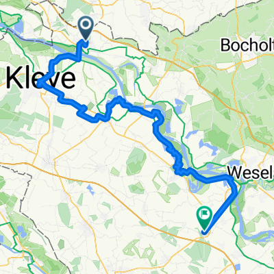
Emmerich-`s-Heerenberg-Ulft-Emmerich
A cycling route starting in Emmerich, North Rhine-Westphalia, Germany.
Overview
About this route
- -:--
- Duration
- 51.3 km
- Distance
- 86 m
- Ascent
- 85 m
- Descent
- ---
- Avg. speed
- 39 m
- Max. altitude
Route quality
Waytypes & surfaces along the route
Waytypes
Quiet road
28.7 km
(56 %)
Cycleway
7.7 km
(15 %)
Surfaces
Paved
30.3 km
(59 %)
Unpaved
1 km
(2 %)
Asphalt
26.2 km
(51 %)
Concrete
2.6 km
(5 %)
Route highlights
Points of interest along the route

Point of interest after 23 km
Aussichtsturm Gendringen

Point of interest after 29.5 km
Wasserschloß Anholt

Point of interest after 31.4 km
Vehlinger Mühle

Point of interest after 35.2 km
Millinger Meer
Continue with Bikemap
Use, edit, or download this cycling route
You would like to ride Emmerich-`s-Heerenberg-Ulft-Emmerich or customize it for your own trip? Here is what you can do with this Bikemap route:
Free features
- Save this route as favorite or in collections
- Copy & plan your own version of this route
- Sync your route with Garmin or Wahoo
Premium features
Free trial for 3 days, or one-time payment. More about Bikemap Premium.
- Navigate this route on iOS & Android
- Export a GPX / KML file of this route
- Create your custom printout (try it for free)
- Download this route for offline navigation
Discover more Premium features.
Get Bikemap PremiumFrom our community
Other popular routes starting in Emmerich
 1. Tag Emmerich-Grieth-Xanten-Rees-Emmerich
- Distance
- 75.4 km
- Ascent
- 108 m
- Descent
- 108 m
- Location
- Emmerich, North Rhine-Westphalia, Germany
 14.07.29 Emmerich a. Rhein-Alpen
- Distance
- 79.2 km
- Ascent
- 49 m
- Descent
- 50 m
- Location
- Emmerich, North Rhine-Westphalia, Germany
 Rund um Emmerich
- Distance
- 46.2 km
- Ascent
- 265 m
- Descent
- 276 m
- Location
- Emmerich, North Rhine-Westphalia, Germany
 RTF-Strecke 111 km Eintracht Emmerich
- Distance
- 100.9 km
- Ascent
- 136 m
- Descent
- 136 m
- Location
- Emmerich, North Rhine-Westphalia, Germany
 Emmerich-`s-Heerenberg-Ulft-Emmerich
- Distance
- 51.3 km
- Ascent
- 86 m
- Descent
- 85 m
- Location
- Emmerich, North Rhine-Westphalia, Germany
 NL171: 't Gelders Eiland - ab/bis Elten
- Distance
- 27.4 km
- Ascent
- 44 m
- Descent
- 44 m
- Location
- Emmerich, North Rhine-Westphalia, Germany
 Emmerich-Xanten-Rees-Emmerich
- Distance
- 74.8 km
- Ascent
- 39 m
- Descent
- 32 m
- Location
- Emmerich, North Rhine-Westphalia, Germany
 Emmerich-Wissel-Kalkar-Kleve-Emmerich
- Distance
- 55.6 km
- Ascent
- 271 m
- Descent
- 271 m
- Location
- Emmerich, North Rhine-Westphalia, Germany
Open it in the app