

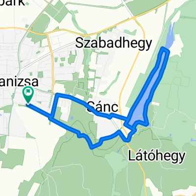
Kis-Balaton kör 2022.04.02
A cycling route starting in Nagykanizsa, Zala County, Hungary.
Overview
About this route
- Nagykanizsa - Zalakaros - Balatonmagyaród kör Táv: 70 km Idő: kb. 3 óra Látnivalók: Kis-Balaton töltés, Kányavári-sziget, Madárvárta, Zalakarosi Fürdő, Termáló, Zalakarosi Parkerdő, Zalakarosi Kilátó Indulási időpont: 13:00
- -:--
- Duration
- 70 km
- Distance
- 428 m
- Ascent
- 428 m
- Descent
- ---
- Avg. speed
- 194 m
- Max. altitude

Route quality
Waytypes & surfaces along the route
Waytypes
Cycleway
22.4 km
(32 %)
Road
3.5 km
(5 %)
Surfaces
Paved
67.2 km
(96 %)
Asphalt
67.2 km
(96 %)
Undefined
2.8 km
(4 %)
Continue with Bikemap
Use, edit, or download this cycling route
You would like to ride Kis-Balaton kör 2022.04.02 or customize it for your own trip? Here is what you can do with this Bikemap route:
Free features
- Save this route as favorite or in collections
- Copy & plan your own version of this route
- Sync your route with Garmin or Wahoo
Premium features
Free trial for 3 days, or one-time payment. More about Bikemap Premium.
- Navigate this route on iOS & Android
- Export a GPX / KML file of this route
- Create your custom printout (try it for free)
- Download this route for offline navigation
Discover more Premium features.
Get Bikemap PremiumFrom our community
Other popular routes starting in Nagykanizsa
 MURA_Kanizsa_50
- Distance
- 49.6 km
- Ascent
- 178 m
- Descent
- 178 m
- Location
- Nagykanizsa, Zala County, Hungary
 Börzönce1
- Distance
- 65.4 km
- Ascent
- 327 m
- Descent
- 327 m
- Location
- Nagykanizsa, Zala County, Hungary
 Bagolai sor, Nagykanizsa - Bagolai sor, Nagykanizsa
- Distance
- 15.9 km
- Ascent
- 77 m
- Descent
- 79 m
- Location
- Nagykanizsa, Zala County, Hungary
 Nagykanizsa-Milánó 2023
- Distance
- 900.9 km
- Ascent
- 4,743 m
- Descent
- 4,759 m
- Location
- Nagykanizsa, Zala County, Hungary
 Várdomb_Homokkomárom_Palin
- Distance
- 18.9 km
- Ascent
- 319 m
- Descent
- 437 m
- Location
- Nagykanizsa, Zala County, Hungary
 Vasút utca, Nagykanizsa - Zgornja Ložnica, Zgornja Ložnica
- Distance
- 153.3 km
- Ascent
- 505 m
- Descent
- 367 m
- Location
- Nagykanizsa, Zala County, Hungary
 Nagykanizsa - Kalinovac
- Distance
- 58 km
- Ascent
- 171 m
- Descent
- 217 m
- Location
- Nagykanizsa, Zala County, Hungary
 Mórichelyi kör
- Distance
- 31 km
- Ascent
- 402 m
- Descent
- 402 m
- Location
- Nagykanizsa, Zala County, Hungary
Open it in the app