

CAD Maisemore 61
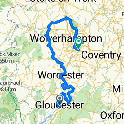
A cycling route starting in Gloucester, England, United Kingdom.
Overview
About this route
CAD refers to a Cycling Away Day ... that is a remote start/finish 'circular' route, from/to a point some substantial distance from home, using car with bike rack to get to that start/finish point. It is, as here, likely to be on largely rural roads with paved surfaces suitable for a road bike.
- -:--
- Duration
- 100.7 km
- Distance
- 692 m
- Ascent
- 692 m
- Descent
- ---
- Avg. speed
- 166 m
- Max. altitude
Continue with Bikemap
Use, edit, or download this cycling route
You would like to ride CAD Maisemore 61 or customize it for your own trip? Here is what you can do with this Bikemap route:
Free features
- Save this route as favorite or in collections
- Copy & plan your own version of this route
- Split it into stages to create a multi-day tour
- Sync your route with Garmin or Wahoo
Premium features
Free trial for 3 days, or one-time payment. More about Bikemap Premium.
- Navigate this route on iOS & Android
- Export a GPX / KML file of this route
- Create your custom printout (try it for free)
- Download this route for offline navigation
Discover more Premium features.
Get Bikemap PremiumFrom our community
Other popular routes starting in Gloucester
 BFCIC26: GLOUCESTER - CHESTER?
- Distance
- 306.7 km
- Ascent
- 2,189 m
- Descent
- 2,067 m
- Location
- Gloucester, England, United Kingdom
 day 10
- Distance
- 103.8 km
- Ascent
- 674 m
- Descent
- 613 m
- Location
- Gloucester, England, United Kingdom
 LEJOG 04 Birtley house guest house telford
- Distance
- 119.8 km
- Ascent
- 672 m
- Descent
- 574 m
- Location
- Gloucester, England, United Kingdom
 Daves 60th birthday 60 mile route
- Distance
- 108.2 km
- Ascent
- 429 m
- Descent
- 426 m
- Location
- Gloucester, England, United Kingdom
 Balanced Gloucester, United Kingdom to North Brewham, South Somerset
- Distance
- 116.7 km
- Ascent
- 467 m
- Descent
- 363 m
- Location
- Gloucester, England, United Kingdom
 Hartpury Loop
- Distance
- 7.7 km
- Ascent
- 42 m
- Descent
- 38 m
- Location
- Gloucester, England, United Kingdom
 Severn Farm, Elmore Lane W, Gloucester to Severn Farm, Elmore Lane W, Gloucester
- Distance
- 17.4 km
- Ascent
- 6 m
- Descent
- 7 m
- Location
- Gloucester, England, United Kingdom
 Amanda Day 4 - Gloucester to Nantwich
- Distance
- 166.7 km
- Ascent
- 340 m
- Descent
- 319 m
- Location
- Gloucester, England, United Kingdom
Open it in the app