

Lower traffic route to work
A cycling route starting in Broomfield, Colorado, United States.
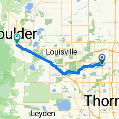
Overview
About this route
Might be lower auto traffic- utilize as many off-street paths as possible. Trickiest/least safe part is in Broomfield. Safer once you get on US 36 bike path. Recommend wearing an air pollution mask whilst riding along US 36.
- -:--
- Duration
- 31.4 km
- Distance
- 310 m
- Ascent
- 300 m
- Descent
- ---
- Avg. speed
- 1,734 m
- Max. altitude
Route quality
Waytypes & surfaces along the route
Waytypes
Cycleway
21 km
(67 %)
Quiet road
5 km
(16 %)
Surfaces
Paved
25.1 km
(80 %)
Unpaved
1.9 km
(6 %)
Concrete
19.4 km
(62 %)
Paved (undefined)
3.8 km
(12 %)
Continue with Bikemap
Use, edit, or download this cycling route
You would like to ride Lower traffic route to work or customize it for your own trip? Here is what you can do with this Bikemap route:
Free features
- Save this route as favorite or in collections
- Copy & plan your own version of this route
- Sync your route with Garmin or Wahoo
Premium features
Free trial for 3 days, or one-time payment. More about Bikemap Premium.
- Navigate this route on iOS & Android
- Export a GPX / KML file of this route
- Create your custom printout (try it for free)
- Download this route for offline navigation
Discover more Premium features.
Get Bikemap PremiumFrom our community
Other popular routes starting in Broomfield
 home from work
- Distance
- 15.4 km
- Ascent
- 245 m
- Descent
- 222 m
- Location
- Broomfield, Colorado, United States
 1395 Dover St, Broomfield to 1395 Dover St, Broomfield
- Distance
- 14 km
- Ascent
- 89 m
- Descent
- 86 m
- Location
- Broomfield, Colorado, United States
 Boulder flagstaff gross res magnolia boulder
- Distance
- 5.4 km
- Ascent
- 127 m
- Descent
- 66 m
- Location
- Broomfield, Colorado, United States
 East 3rd Avenue 930, Broomfield to East 3rd Avenue 930, Broomfield
- Distance
- 38.1 km
- Ascent
- 365 m
- Descent
- 366 m
- Location
- Broomfield, Colorado, United States
 2468 McKay Landing Pkwy, Broomfield to 245 30th St, Boulder
- Distance
- 30.2 km
- Ascent
- 1,909 m
- Descent
- 1,867 m
- Location
- Broomfield, Colorado, United States
 763 Eldorado Blvd, Broomfield to 763 Eldorado Blvd, Broomfield
- Distance
- 8.9 km
- Ascent
- 103 m
- Descent
- 104 m
- Location
- Broomfield, Colorado, United States
 Jersey mikes
- Distance
- 4.2 km
- Ascent
- 17 m
- Descent
- 27 m
- Location
- Broomfield, Colorado, United States
 - RTD Buses Only
- Distance
- 12.5 km
- Ascent
- 120 m
- Descent
- 93 m
- Location
- Broomfield, Colorado, United States
Open it in the app