

Tata oda
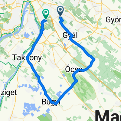
A cycling route starting in Budapest XVIII. kerület, Budapest, Hungary.
Overview
About this route
- -:--
- Duration
- 98.7 km
- Distance
- 685 m
- Ascent
- 689 m
- Descent
- ---
- Avg. speed
- 393 m
- Max. altitude

Route quality
Waytypes & surfaces along the route
Waytypes
Quiet road
33.5 km
(34 %)
Cycleway
13.8 km
(14 %)
Surfaces
Paved
79.9 km
(81 %)
Unpaved
3 km
(3 %)
Asphalt
78.9 km
(80 %)
Paved (undefined)
1 km
(1 %)
Continue with Bikemap
Use, edit, or download this cycling route
You would like to ride Tata oda or customize it for your own trip? Here is what you can do with this Bikemap route:
Free features
- Save this route as favorite or in collections
- Copy & plan your own version of this route
- Split it into stages to create a multi-day tour
- Sync your route with Garmin or Wahoo
Premium features
Free trial for 3 days, or one-time payment. More about Bikemap Premium.
- Navigate this route on iOS & Android
- Export a GPX / KML file of this route
- Create your custom printout (try it for free)
- Download this route for offline navigation
Discover more Premium features.
Get Bikemap PremiumFrom our community
Other popular routes starting in Budapest XVIII. kerület
 Lujza utca, Budapest - Lujza utca, Budapest
- Distance
- 5.5 km
- Ascent
- 52 m
- Descent
- 50 m
- Location
- Budapest XVIII. kerület, Budapest, Hungary
 Budapest-Nagybörzsöny
- Distance
- 95.9 km
- Ascent
- 884 m
- Descent
- 788 m
- Location
- Budapest XVIII. kerület, Budapest, Hungary
 Untitled route
- Distance
- 98.5 km
- Ascent
- 676 m
- Descent
- 671 m
- Location
- Budapest XVIII. kerület, Budapest, Hungary
 P.lőtinc- Videgrád-Zebegény-Vác
- Distance
- 93.8 km
- Ascent
- 765 m
- Descent
- 838 m
- Location
- Budapest XVIII. kerület, Budapest, Hungary
 8 km a 18. kerületben
- Distance
- 8.2 km
- Ascent
- 25 m
- Descent
- 25 m
- Location
- Budapest XVIII. kerület, Budapest, Hungary
 From Budapest to Velence
- Distance
- 76.7 km
- Ascent
- 623 m
- Descent
- 637 m
- Location
- Budapest XVIII. kerület, Budapest, Hungary
 Raktárból Cserihez
- Distance
- 5.8 km
- Ascent
- 4 m
- Descent
- 4 m
- Location
- Budapest XVIII. kerület, Budapest, Hungary
 Bugyikör
- Distance
- 62.9 km
- Ascent
- 43 m
- Descent
- 71 m
- Location
- Budapest XVIII. kerület, Budapest, Hungary
Open it in the app