

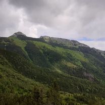
Velo Dunajec
A cycling route starting in Zakopane, Lesser Poland Voivodeship, Poland.
Overview
About this route
- -:--
- Duration
- 224.6 km
- Distance
- 1,634 m
- Ascent
- 2,214 m
- Descent
- ---
- Avg. speed
- 839 m
- Max. altitude

Route quality
Waytypes & surfaces along the route
Waytypes
Cycleway
82.6 km
(37 %)
Quiet road
53.6 km
(24 %)
Surfaces
Paved
196.1 km
(87 %)
Unpaved
5 km
(2 %)
Asphalt
178.2 km
(79 %)
Paving stones
10.9 km
(5 %)
Route highlights
Points of interest along the route
Photo after 13.8 km
Muzeum oscypka
Photo after 18.3 km
Ruiny zamku i jaskinia w Szaflarach.
Photo after 60.7 km
Zamek w Niedzicy
Accommodation after 63 km
Nocleg
Photo after 75.8 km
Muzeum klasztorne
Accommodation after 126 km
Photo after 137.2 km
Ruiny zamku w Nowym Sączu.
Drinking water after 146.8 km
Winnica Gródek
Photo after 164.2 km
Ruiny zamku w Różnowie
Accommodation after 166.2 km
Photo after 169.4 km
Zamek w Różnowie.
Photo after 177.1 km
Zamek Tropsztyn
Photo after 180.7 km
Elektrownia wodna Czchów
Continue with Bikemap
Use, edit, or download this cycling route
You would like to ride Velo Dunajec or customize it for your own trip? Here is what you can do with this Bikemap route:
Free features
- Save this route as favorite or in collections
- Copy & plan your own version of this route
- Split it into stages to create a multi-day tour
- Sync your route with Garmin or Wahoo
Premium features
Free trial for 3 days, or one-time payment. More about Bikemap Premium.
- Navigate this route on iOS & Android
- Export a GPX / KML file of this route
- Create your custom printout (try it for free)
- Download this route for offline navigation
Discover more Premium features.
Get Bikemap PremiumFrom our community
Other popular routes starting in Zakopane
 Day 2 Easier option
- Distance
- 15.5 km
- Ascent
- 661 m
- Descent
- 664 m
- Location
- Zakopane, Lesser Poland Voivodeship, Poland
 D03ZaNoSa
- Distance
- 100.1 km
- Ascent
- 256 m
- Descent
- 820 m
- Location
- Zakopane, Lesser Poland Voivodeship, Poland
 Día 3. Zakopane Kezmarok
- Distance
- 70.8 km
- Ascent
- 889 m
- Descent
- 1,114 m
- Location
- Zakopane, Lesser Poland Voivodeship, Poland
 D03v1ZaNoSa
- Distance
- 92.1 km
- Ascent
- 336 m
- Descent
- 900 m
- Location
- Zakopane, Lesser Poland Voivodeship, Poland
 10.08.18 tour de Zako
- Distance
- 77.1 km
- Ascent
- 2,779 m
- Descent
- 2,761 m
- Location
- Zakopane, Lesser Poland Voivodeship, Poland
 13.07.20 Kopa Kondracka
- Distance
- 13.1 km
- Ascent
- 967 m
- Descent
- 962 m
- Location
- Zakopane, Lesser Poland Voivodeship, Poland
 OSTURNA (przez Gliczarów-nie jak TdP oraz nową drogą z Wyżniego Końca i Zdiarskie sedlo) - 3-10-15
- Distance
- 90 km
- Ascent
- 1,419 m
- Descent
- 1,417 m
- Location
- Zakopane, Lesser Poland Voivodeship, Poland
 23.7.2018
- Distance
- 55.6 km
- Ascent
- 784 m
- Descent
- 784 m
- Location
- Zakopane, Lesser Poland Voivodeship, Poland
Open it in the app