

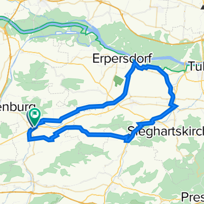
JEUTENDORF Alte Perschling - Runde
A cycling route starting in Kapelln, Lower Austria, Austria.
Overview
About this route
- -:--
- Duration
- 52.2 km
- Distance
- 347 m
- Ascent
- 347 m
- Descent
- ---
- Avg. speed
- 288 m
- Max. altitude

Route quality
Waytypes & surfaces along the route
Waytypes
Road
25.1 km
(48 %)
Track
15.1 km
(29 %)
Surfaces
Paved
16.7 km
(32 %)
Unpaved
12.5 km
(24 %)
Asphalt
14.1 km
(27 %)
Gravel
9.4 km
(18 %)
Route highlights
Points of interest along the route
Point of interest after 2.6 km
Kirche Kapelln
Point of interest after 5.1 km
Landesmittelpunkt
Point of interest after 8.6 km
Kirche Weißenkirchen
Point of interest after 9.4 km
Altes Posthaus
Point of interest after 17.5 km
Schusterberg
Point of interest after 23.2 km
Schloss Atzenbrugg
Point of interest after 35.6 km
Würmla´s Wände / Samowar
Point of interest after 36.9 km
Würmla´s Wände / Milchmann
Point of interest after 37 km
Würmla´s Wände / Eisengewichte
Point of interest after 39.1 km
Althann-Mausoleum
Point of interest after 42.9 km
Schloss Thalheim
Continue with Bikemap
Use, edit, or download this cycling route
You would like to ride JEUTENDORF Alte Perschling - Runde or customize it for your own trip? Here is what you can do with this Bikemap route:
Free features
- Save this route as favorite or in collections
- Copy & plan your own version of this route
- Sync your route with Garmin or Wahoo
Premium features
Free trial for 3 days, or one-time payment. More about Bikemap Premium.
- Navigate this route on iOS & Android
- Export a GPX / KML file of this route
- Create your custom printout (try it for free)
- Download this route for offline navigation
Discover more Premium features.
Get Bikemap PremiumFrom our community
Other popular routes starting in Kapelln
 Tullnerfeld
- Distance
- 54.3 km
- Ascent
- 221 m
- Descent
- 222 m
- Location
- Kapelln, Lower Austria, Austria
 Bahnstrasse-Große Tulln-Neulengbach
- Distance
- 64.2 km
- Ascent
- 309 m
- Descent
- 308 m
- Location
- Kapelln, Lower Austria, Austria
 Pottenbrunn -Türnitz-Pottenbrunn 102km 2019_09_15
- Distance
- 101.5 km
- Ascent
- 2,718 m
- Descent
- 2,718 m
- Location
- Kapelln, Lower Austria, Austria
 Kapelln
- Distance
- 17.9 km
- Ascent
- 166 m
- Descent
- 166 m
- Location
- Kapelln, Lower Austria, Austria
 JEUTENDORF Alte Perschling - Runde
- Distance
- 52.2 km
- Ascent
- 347 m
- Descent
- 347 m
- Location
- Kapelln, Lower Austria, Austria
 Perschlingtal Route
- Distance
- 57.3 km
- Ascent
- 254 m
- Descent
- 253 m
- Location
- Kapelln, Lower Austria, Austria
 Perschlingtalradweg- Tullnradweg
- Distance
- 62.1 km
- Ascent
- 106 m
- Descent
- 105 m
- Location
- Kapelln, Lower Austria, Austria
 radfahrweg
- Distance
- 12.4 km
- Ascent
- 165 m
- Descent
- 153 m
- Location
- Kapelln, Lower Austria, Austria
Open it in the app