

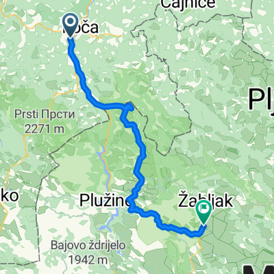
Stari Dud - Kamp Šarban, Dobri do
A cycling route starting in Foča, Republika Srpska, Bosnia and Herzegovina.
Overview
About this route
- -:--
- Duration
- 71.9 km
- Distance
- 2,385 m
- Ascent
- 1,106 m
- Descent
- ---
- Avg. speed
- 1,882 m
- Max. altitude

Route quality
Waytypes & surfaces along the route
Waytypes
Road
33.8 km
(47 %)
Undefined
38.1 km
(53 %)
Surfaces
Paved
71.9 km
(100 %)
Asphalt
71.9 km
(100 %)
Continue with Bikemap
Use, edit, or download this cycling route
You would like to ride Stari Dud - Kamp Šarban, Dobri do or customize it for your own trip? Here is what you can do with this Bikemap route:
Free features
- Save this route as favorite or in collections
- Copy & plan your own version of this route
- Sync your route with Garmin or Wahoo
Premium features
Free trial for 3 days, or one-time payment. More about Bikemap Premium.
- Navigate this route on iOS & Android
- Export a GPX / KML file of this route
- Create your custom printout (try it for free)
- Download this route for offline navigation
Discover more Premium features.
Get Bikemap PremiumFrom our community
Other popular routes starting in Foča
 tjentiste.durmitor 5 tappa
- Distance
- 120 km
- Ascent
- 2,318 m
- Descent
- 1,576 m
- Location
- Foča, Republika Srpska, Bosnia and Herzegovina
 4. Tag Gasthaus Antik Foca- Etno Selo Sljeme
- Distance
- 88.1 km
- Ascent
- 1,981 m
- Descent
- 884 m
- Location
- Foča, Republika Srpska, Bosnia and Herzegovina
 Foča-SandPyramids-Ustikolina
- Distance
- 36.2 km
- Ascent
- 803 m
- Descent
- 851 m
- Location
- Foča, Republika Srpska, Bosnia and Herzegovina
 mdutvonal10
- Distance
- 94.7 km
- Ascent
- 1,509 m
- Descent
- 1,012 m
- Location
- Foča, Republika Srpska, Bosnia and Herzegovina
 Bosnija 18.diena Popov Most-Bileca
- Distance
- 74.1 km
- Ascent
- 920 m
- Descent
- 1,025 m
- Location
- Foča, Republika Srpska, Bosnia and Herzegovina
 Day 89
- Distance
- 50.9 km
- Ascent
- 2,152 m
- Descent
- 1,837 m
- Location
- Foča, Republika Srpska, Bosnia and Herzegovina
 11B. Foca-Sarajevo
- Distance
- 83.2 km
- Ascent
- 853 m
- Descent
- 735 m
- Location
- Foča, Republika Srpska, Bosnia and Herzegovina
 Tjentiste-Orovacko jezero 1
- Distance
- 47.6 km
- Ascent
- 1,973 m
- Descent
- 1,082 m
- Location
- Foča, Republika Srpska, Bosnia and Herzegovina
Open it in the app