
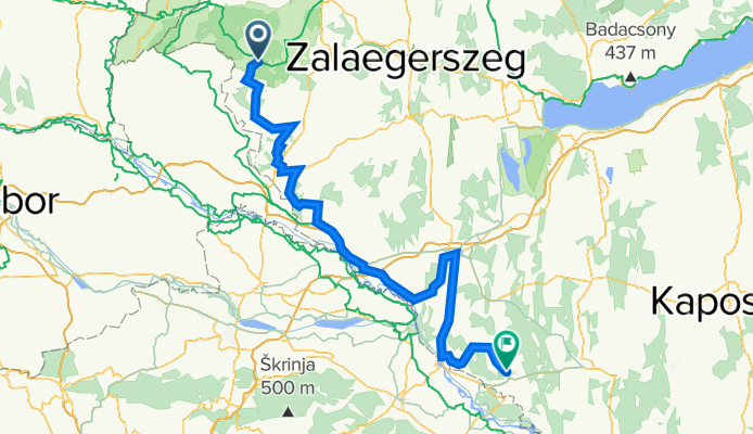
Túra a Déli Védelmi Rendszer mentén
A cycling route starting in Zalalövő, Zala County, Hungary.
Overview
About this route
Túra a Déli Védelmi Rendszer mentén
Őriszentpéter-- Lenti - Tornyiszentmiklós - Letenye Murakeresztúr - Nagykanizsa - Berzence
- -:--
- Duration
- 157.6 km
- Distance
- 801 m
- Ascent
- 891 m
- Descent
- ---
- Avg. speed
- 327 m
- Max. altitude

Route quality
Waytypes & surfaces along the route
Waytypes
Busy road
114.6 km
(73 %)
Quiet road
18 km
(11 %)
Surfaces
Paved
44.3 km
(28 %)
Unpaved
0.8 km
(<1 %)
Asphalt
42.6 km
(27 %)
Paved (undefined)
1.8 km
(1 %)
Route highlights
Points of interest along the route
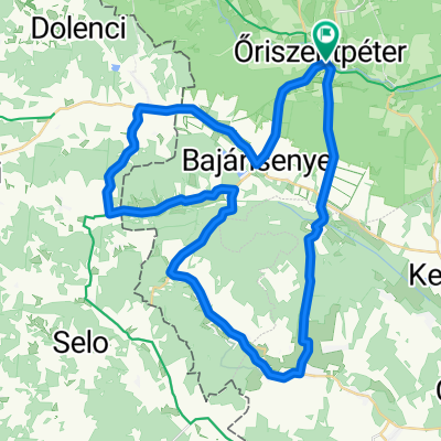
Point of interest after 5 km
1002. bajánsenye Zászlóalj-védőkörlet
Point of interest after 23.1 km
1005. Nemesnép Zászlóalj-védőkörlet
Point of interest after 28.5 km
1175. CsesztregZászlóalj-védőkörlet
Point of interest after 35.8 km
1006. Resznek Zászlóalj-védőkörlet
Point of interest after 38.5 km
1007. Belsősárd Zászlóalj-védőkörlet
Point of interest after 42.1 km
1008. Rédics Zászlóalj-védőkörlet
Point of interest after 56.3 km
LT-3 tankállomás
Point of interest after 58.2 km
1129/A Lovászi Zászlóalj-védőkörlet
Point of interest after 61.8 km
1042 csömödér
Point of interest after 63 km
1130/A Tormafölde Zászlóalj-védőkörlet
Point of interest after 65.5 km
1012 Tornyiszentmiklós Zászlóalj-védőkörlet
Point of interest after 65.5 km
1013 Dobri Zászlóalj-védőkörlet
Point of interest after 76.3 km
Murarátka Zászlóalj-védőkörlet
Point of interest after 80.9 km
1017 Letenye Zászlóalj-védőkörlet
Point of interest after 90.1 km
1021 Tótszentmárton Zászlóalj-védőkörlet
Point of interest after 98.8 km
1025 Murakeresztúr Zászlóalj-védőkörlet
Point of interest after 102.4 km
1023 Fityeház Zászlóalj-védőkörlet
Point of interest after 106.5 km
1180 .Bajcsa Zászlóalj-védőkörlet
Point of interest after 109.2 km
1179 Szepetnek Zászlóalj-védőkörlet
Point of interest after 116.1 km
1243 Nemesvid Zászlóalj-védőkörlet
Point of interest after 116.1 km
1226 Galambok Zászlóalj-védőkörlet
Point of interest after 135.2 km
1027. Zákány Zászlóalj-védőkörlet
Point of interest after 151 km
1221 Somogycsicsó Zászlóalj-védőkörlet
Point of interest after 154.1 km
1029 Alsok Zászlóalj-védőkörlet
Continue with Bikemap
Use, edit, or download this cycling route
You would like to ride Túra a Déli Védelmi Rendszer mentén or customize it for your own trip? Here is what you can do with this Bikemap route:
Free features
- Save this route as favorite or in collections
- Copy & plan your own version of this route
- Split it into stages to create a multi-day tour
- Sync your route with Garmin or Wahoo
Premium features
Free trial for 3 days, or one-time payment. More about Bikemap Premium.
- Navigate this route on iOS & Android
- Export a GPX / KML file of this route
- Create your custom printout (try it for free)
- Download this route for offline navigation
Discover more Premium features.
Get Bikemap PremiumFrom our community
Other popular routes starting in Zalalövő
 Őrség 1 Kerékpárútvonal
- Distance
- 33.8 km
- Ascent
- 241 m
- Descent
- 246 m
- Location
- Zalalövő, Zala County, Hungary
 Vendvidék - Goricko kör
- Distance
- 85.6 km
- Ascent
- 632 m
- Descent
- 619 m
- Location
- Zalalövő, Zala County, Hungary
 Őrség 3.
- Distance
- 63.2 km
- Ascent
- 196 m
- Descent
- 218 m
- Location
- Zalalövő, Zala County, Hungary
 Öriszentpéter - északnyugati hurok
- Distance
- 40.6 km
- Ascent
- 397 m
- Descent
- 397 m
- Location
- Zalalövő, Zala County, Hungary
 Őrség túra 62km
- Distance
- 61.6 km
- Ascent
- 270 m
- Descent
- 260 m
- Location
- Zalalövő, Zala County, Hungary
 Oriszentpeter 1
- Distance
- 47.7 km
- Ascent
- 355 m
- Descent
- 355 m
- Location
- Zalalövő, Zala County, Hungary
 Őrség kör
- Distance
- 54.2 km
- Ascent
- 890 m
- Descent
- 661 m
- Location
- Zalalövő, Zala County, Hungary
 Túra a Bakonaki-tóhoz
- Distance
- 72.2 km
- Ascent
- 546 m
- Descent
- 547 m
- Location
- Zalalövő, Zala County, Hungary
Open it in the app