

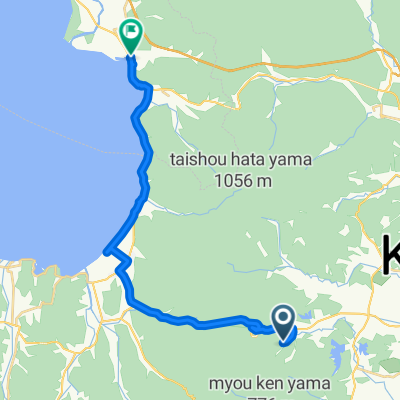
35-3, Fukuyamamachikubota Tarodonomae, Koriyama to Taki Kaya, Miharu, Tamura-Gun
A cycling route starting in Kōriyama, Fukushima, Japan.
Overview
About this route
- 1 h 18 min
- Duration
- 13.3 km
- Distance
- 338 m
- Ascent
- 224 m
- Descent
- 10.2 km/h
- Avg. speed
- 382 m
- Max. altitude

Continue with Bikemap
Use, edit, or download this cycling route
You would like to ride 35-3, Fukuyamamachikubota Tarodonomae, Koriyama to Taki Kaya, Miharu, Tamura-Gun or customize it for your own trip? Here is what you can do with this Bikemap route:
Free features
- Save this route as favorite or in collections
- Copy & plan your own version of this route
- Sync your route with Garmin or Wahoo
Premium features
Free trial for 3 days, or one-time payment. More about Bikemap Premium.
- Navigate this route on iOS & Android
- Export a GPX / KML file of this route
- Create your custom printout (try it for free)
- Download this route for offline navigation
Discover more Premium features.
Get Bikemap PremiumFrom our community
Other popular routes starting in Kōriyama
 2017/09/16会津ゴールドライン
- Distance
- 147 km
- Ascent
- 1,086 m
- Descent
- 1,569 m
- Location
- Kōriyama, Fukushima, Japan
 5/3 GW 登山原発ツアー Day3
- Distance
- 50.4 km
- Ascent
- 888 m
- Descent
- 921 m
- Location
- Kōriyama, Fukushima, Japan
 michinoku cycling road
- Distance
- 26.8 km
- Ascent
- 203 m
- Descent
- 203 m
- Location
- Kōriyama, Fukushima, Japan
 Cycle 3: Koriyama - Iwaki
- Distance
- 81.9 km
- Ascent
- 727 m
- Descent
- 946 m
- Location
- Kōriyama, Fukushima, Japan
 day 9 to campsite lake Inawashiro 31km
- Distance
- 41.1 km
- Ascent
- 488 m
- Descent
- 396 m
- Location
- Kōriyama, Fukushima, Japan
 Genda, Koriyama to Maehama, Inawashiro
- Distance
- 24.2 km
- Ascent
- 354 m
- Descent
- 267 m
- Location
- Kōriyama, Fukushima, Japan
 35-3, Fukuyamamachikubota Tarodonomae, Koriyama to Taki Kaya, Miharu, Tamura-Gun
- Distance
- 13.3 km
- Ascent
- 338 m
- Descent
- 224 m
- Location
- Kōriyama, Fukushima, Japan
 Koriyama to Mountain Lake Kitashiobara
- Distance
- 59 km
- Ascent
- 1,631 m
- Descent
- 1,035 m
- Location
- Kōriyama, Fukushima, Japan
Open it in the app