
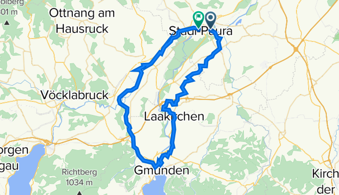
Lambach - Bad Wimsbach - Kurpark Neydharting - Gmunden - Pinsdorf - Aurachtal - Puchheim - Ager Ufer Weg
A cycling route starting in Lambach, Upper Austria, Austria.
Overview
About this route
- 3 h 37 min
- Duration
- 69.5 km
- Distance
- 419 m
- Ascent
- 441 m
- Descent
- 19.2 km/h
- Avg. speed
- 502 m
- Max. altitude

Continue with Bikemap
Use, edit, or download this cycling route
You would like to ride Lambach - Bad Wimsbach - Kurpark Neydharting - Gmunden - Pinsdorf - Aurachtal - Puchheim - Ager Ufer Weg or customize it for your own trip? Here is what you can do with this Bikemap route:
Free features
- Save this route as favorite or in collections
- Copy & plan your own version of this route
- Sync your route with Garmin or Wahoo
Premium features
Free trial for 3 days, or one-time payment. More about Bikemap Premium.
- Navigate this route on iOS & Android
- Export a GPX / KML file of this route
- Create your custom printout (try it for free)
- Download this route for offline navigation
Discover more Premium features.
Get Bikemap PremiumFrom our community
Other popular routes starting in Lambach
 Lambach-Molln
- Distance
- 65.4 km
- Ascent
- 479 m
- Descent
- 384 m
- Location
- Lambach, Upper Austria, Austria
 kemal 1
- Distance
- 26.4 km
- Ascent
- 25 m
- Descent
- 95 m
- Location
- Lambach, Upper Austria, Austria
 Lambach - Bad Wimsbach - Kurpark Neydharting - Gmunden - Pinsdorf - Aurachtal - Puchheim - Ager Ufer Weg
- Distance
- 69.5 km
- Ascent
- 419 m
- Descent
- 441 m
- Location
- Lambach, Upper Austria, Austria
 Lambach Bhf R106 Süd + Nordschleife zu V1a/V1 Innbach Radweg und R6 (Vökla) / R4 Traun Radweg
- Distance
- 58.4 km
- Ascent
- 919 m
- Descent
- 916 m
- Location
- Lambach, Upper Austria, Austria
 Teilstück von R4 OÖ
- Distance
- 50.6 km
- Ascent
- 605 m
- Descent
- 588 m
- Location
- Lambach, Upper Austria, Austria
 Gemütliche Route in Edt bei Lambach
- Distance
- 25.8 km
- Ascent
- 148 m
- Descent
- 146 m
- Location
- Lambach, Upper Austria, Austria
 Hausruck, Kobernauserrunde
- Distance
- 131.1 km
- Ascent
- 1,220 m
- Descent
- 1,220 m
- Location
- Lambach, Upper Austria, Austria
 Lambach Bad Gams
- Distance
- 257.4 km
- Ascent
- 2,422 m
- Descent
- 2,415 m
- Location
- Lambach, Upper Austria, Austria
Open it in the app