Untersuhl-Säulingswald- Untersuhl
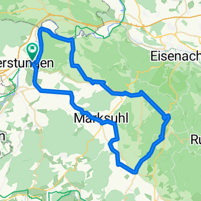
A cycling route starting in Gerstungen, Thuringia, Germany.
Overview
About this route
From Untersuhl, we go along the Werra cycling path until Widdershausen. Then we turn right and ride across the fields towards Bengendorf, crossing the L 3306 towards Forsthaus and Wolfram Wolf Hütte. We continue until we cross the A4 and then turn left towards Friedewald. Just before Friedewald, we turn north, finally making our way back east and take a short detour at Keils-Haus (unfortunately closed). Then we continue generally towards Ronshausen, riding a short distance along the L 3251 before turning left to tackle a reasonable ascent toward Ulfe-Quelle. From there we return via the R 12 towards Hönebach, through the railway rescue path to Obersuhl and the cycle path back to Untersuhl.
- -:--
- Duration
- 69.3 km
- Distance
- 1,249 m
- Ascent
- 1,250 m
- Descent
- ---
- Avg. speed
- 483 m
- Max. altitude
Continue with Bikemap
Use, edit, or download this cycling route
You would like to ride Untersuhl-Säulingswald- Untersuhl or customize it for your own trip? Here is what you can do with this Bikemap route:
Free features
- Save this route as favorite or in collections
- Copy & plan your own version of this route
- Sync your route with Garmin or Wahoo
Premium features
Free trial for 3 days, or one-time payment. More about Bikemap Premium.
- Navigate this route on iOS & Android
- Export a GPX / KML file of this route
- Create your custom printout (try it for free)
- Download this route for offline navigation
Discover more Premium features.
Get Bikemap PremiumFrom our community
Other popular routes starting in Gerstungen
- Untersuhl- Dankmarshausen- Widdershausen- Kaliberg- Bengendorf- Wolfram Wolf Hütte- Richtung Hammundeseiche- A4 Überquerung- Hönebach- Bosserode- Obersuhl- Unte
- Distance
- 37.9 km
- Ascent
- 482 m
- Descent
- 482 m
- Location
- Gerstungen, Thuringia, Germany
- Gerstungen
- Distance
- 27.4 km
- Ascent
- 142 m
- Descent
- 140 m
- Location
- Gerstungen, Thuringia, Germany
- Untersuhl- Kratzeroda- Sallmannshäuser Rennsteig- Unterellen- Rangenhof- Clausberg- Sängerwiese- Wartburg- ESA- Stedtfelder Teiche- Lauchröden- Böller- Sallmann
- Distance
- 63.7 km
- Ascent
- 2,040 m
- Descent
- 2,262 m
- Location
- Gerstungen, Thuringia, Germany
- Untersuhl-Richtung Autobahn-BrackEiche-Kohlbachquelle-Kohlbachhaus-Richtung Kirche-Neustaedt-Sallmannshausen-Werraradwanderweg-Gerstungen-Untersuhl
- Distance
- 27.1 km
- Ascent
- 0 m
- Descent
- 216 m
- Location
- Gerstungen, Thuringia, Germany
- Untersuhl-Säulingswald- Untersuhl
- Distance
- 69.3 km
- Ascent
- 1,249 m
- Descent
- 1,250 m
- Location
- Gerstungen, Thuringia, Germany
- Untersuhl- Berka- Abteroda- Springen- Kieselbach- Krayenburg- Tiefenort- Dönges- Fernbreitenbach- Gerstungen- Untersuhl
- Distance
- 51.1 km
- Ascent
- 755 m
- Descent
- 755 m
- Location
- Gerstungen, Thuringia, Germany
- 6 HeimatTour GPX3_Garmin
- Distance
- 83.6 km
- Ascent
- 481 m
- Descent
- 457 m
- Location
- Gerstungen, Thuringia, Germany
- 08.08.2019 Gerstungen - Eisenach
- Distance
- 27.1 km
- Ascent
- 161 m
- Descent
- 157 m
- Location
- Gerstungen, Thuringia, Germany
Open it in the app