

Rad 37km Nff-Kohlbg-Metzg-Ntenzlg-Ntailfg-Wg
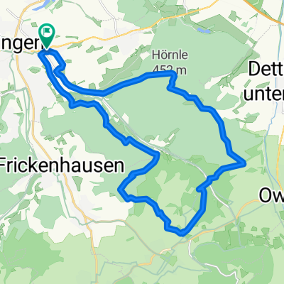
A cycling route starting in Nürtingen, Baden-Wurttemberg, Germany.
Overview
About this route
- -:--
- Duration
- 37.9 km
- Distance
- 411 m
- Ascent
- 389 m
- Descent
- ---
- Avg. speed
- 498 m
- Max. altitude
Route quality
Waytypes & surfaces along the route
Waytypes
Quiet road
8.3 km
(22 %)
Road
6.4 km
(17 %)
Surfaces
Paved
33 km
(87 %)
Asphalt
26.9 km
(71 %)
Paved (undefined)
6.1 km
(16 %)
Undefined
4.9 km
(13 %)
Continue with Bikemap
Use, edit, or download this cycling route
You would like to ride Rad 37km Nff-Kohlbg-Metzg-Ntenzlg-Ntailfg-Wg or customize it for your own trip? Here is what you can do with this Bikemap route:
Free features
- Save this route as favorite or in collections
- Copy & plan your own version of this route
- Sync your route with Garmin or Wahoo
Premium features
Free trial for 3 days, or one-time payment. More about Bikemap Premium.
- Navigate this route on iOS & Android
- Export a GPX / KML file of this route
- Create your custom printout (try it for free)
- Download this route for offline navigation
Discover more Premium features.
Get Bikemap PremiumFrom our community
Other popular routes starting in Nürtingen
 Alb-Panorama
- Distance
- 60.4 km
- Ascent
- 419 m
- Descent
- 416 m
- Location
- Nürtingen, Baden-Wurttemberg, Germany
 Neckartalradweg Ntg - Tü
- Distance
- 64.4 km
- Ascent
- 406 m
- Descent
- 396 m
- Location
- Nürtingen, Baden-Wurttemberg, Germany
 nürtingen-Weiler Hütte
- Distance
- 40.7 km
- Ascent
- 303 m
- Descent
- 259 m
- Location
- Nürtingen, Baden-Wurttemberg, Germany
 Gerber Bräu - Hirschgarten - Reuschwald
- Distance
- 68.6 km
- Ascent
- 357 m
- Descent
- 357 m
- Location
- Nürtingen, Baden-Wurttemberg, Germany
 2010-Tag9: Nürtlingen-Geradstetten (Zelt)
- Distance
- 56.5 km
- Ascent
- 169 m
- Descent
- 201 m
- Location
- Nürtingen, Baden-Wurttemberg, Germany
 NT Rundtour an NT beidseitig Tiefenbachtal
- Distance
- 22.6 km
- Ascent
- 410 m
- Descent
- 410 m
- Location
- Nürtingen, Baden-Wurttemberg, Germany
 Die Hügel von Nürtingen
- Distance
- 16.5 km
- Ascent
- 231 m
- Descent
- 231 m
- Location
- Nürtingen, Baden-Wurttemberg, Germany
 Nürtingen-Lämmerbuckel und zurück
- Distance
- 86.8 km
- Ascent
- 1,257 m
- Descent
- 1,183 m
- Location
- Nürtingen, Baden-Wurttemberg, Germany
Open it in the app