

The optimized experience
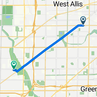
A cycling route starting in West Allis, Wisconsin, United States.
Overview
About this route
- -:--
- Duration
- 25 km
- Distance
- 138 m
- Ascent
- 139 m
- Descent
- ---
- Avg. speed
- 251 m
- Max. altitude

Route highlights
Points of interest along the route
Point of interest after 2.3 km
Alcott
Point of interest after 11.3 km
Waterfall
Point of interest after 14.4 km
Pool house
Point of interest after 14.7 km
Edge circle
Point of interest after 14.9 km
Old condo
Point of interest after 15.2 km
Secret entrance
Point of interest after 15.7 km
Wehr Nature trail
Point of interest after 18.2 km
MCD
Continue with Bikemap
Use, edit, or download this cycling route
You would like to ride The optimized experience or customize it for your own trip? Here is what you can do with this Bikemap route:
Free features
- Save this route as favorite or in collections
- Copy & plan your own version of this route
- Sync your route with Garmin or Wahoo
Premium features
Free trial for 3 days, or one-time payment. More about Bikemap Premium.
- Navigate this route on iOS & Android
- Export a GPX / KML file of this route
- Create your custom printout (try it for free)
- Download this route for offline navigation
Discover more Premium features.
Get Bikemap PremiumFrom our community
Other popular routes starting in West Allis
 10.7 Miles
- Distance
- 17.2 km
- Ascent
- 80 m
- Descent
- 78 m
- Location
- West Allis, Wisconsin, United States
 Lengthy bike tour through West Allis
- Distance
- 34.7 km
- Ascent
- 104 m
- Descent
- 102 m
- Location
- West Allis, Wisconsin, United States
 Hank Aaron State Trail, West Allis to 16665 Brehon Ln, Brookfield
- Distance
- 12.4 km
- Ascent
- 66 m
- Descent
- 44 m
- Location
- West Allis, Wisconsin, United States
 West Allis to Elegant Farmer
- Distance
- 81.4 km
- Ascent
- 261 m
- Descent
- 223 m
- Location
- West Allis, Wisconsin, United States
 1456 S 76th St, West Allis to 225 S Canal St, Chicago
- Distance
- 152 km
- Ascent
- 282 m
- Descent
- 320 m
- Location
- West Allis, Wisconsin, United States
 Home to Work
- Distance
- 6.8 km
- Ascent
- 63 m
- Descent
- 50 m
- Location
- West Allis, Wisconsin, United States
 The optimized experience
- Distance
- 25 km
- Ascent
- 138 m
- Descent
- 139 m
- Location
- West Allis, Wisconsin, United States
 Hank Aaron State Trail, West Allis to Hank Aaron State Trail, West Allis
- Distance
- 3.7 km
- Ascent
- 9 m
- Descent
- 12 m
- Location
- West Allis, Wisconsin, United States
Open it in the app