

2. Etappe Badetag unter 100 km
A cycling route starting in Lauchröden, Thuringia, Germany.
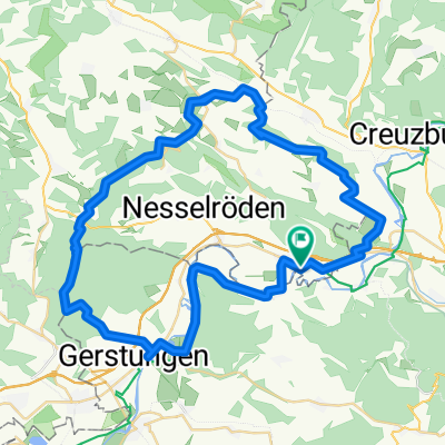
Overview
About this route
The route planner does not accept shortcuts
- -:--
- Duration
- 111.5 km
- Distance
- 751 m
- Ascent
- 815 m
- Descent
- ---
- Avg. speed
- 233 m
- Max. altitude

Route quality
Waytypes & surfaces along the route
Waytypes
Track
46.8 km
(42 %)
Path
23.4 km
(21 %)
Surfaces
Paved
94.8 km
(85 %)
Unpaved
12.3 km
(11 %)
Asphalt
84.8 km
(76 %)
Gravel
10 km
(9 %)
Route highlights
Points of interest along the route
Point of interest after 36 km
siemonsruh
Point of interest after 44 km
schutzhütte
Point of interest after 71.2 km
fischerstübchen
Point of interest after 78 km
hhütte
Point of interest after 78.3 km
pfeillietenhütte?
Point of interest after 80.1 km
hütte
Point of interest after 84.3 km
hütte
Point of interest after 90 km
wehr zum übersteigen
Point of interest after 111.5 km
camingplatz mit gasthof
Point of interest after 111.5 km
kurzer steiler anstieg hütte
Continue with Bikemap
Use, edit, or download this cycling route
You would like to ride 2. Etappe Badetag unter 100 km or customize it for your own trip? Here is what you can do with this Bikemap route:
Free features
- Save this route as favorite or in collections
- Copy & plan your own version of this route
- Split it into stages to create a multi-day tour
- Sync your route with Garmin or Wahoo
Premium features
Free trial for 3 days, or one-time payment. More about Bikemap Premium.
- Navigate this route on iOS & Android
- Export a GPX / KML file of this route
- Create your custom printout (try it for free)
- Download this route for offline navigation
Discover more Premium features.
Get Bikemap PremiumFrom our community
Other popular routes starting in Lauchröden
 Große Runde
- Distance
- 38.3 km
- Ascent
- 261 m
- Descent
- 261 m
- Location
- Lauchröden, Thuringia, Germany
 Unterellen - Vachaer Stein
- Distance
- 21.3 km
- Ascent
- 265 m
- Descent
- 265 m
- Location
- Lauchröden, Thuringia, Germany
 Grenzerfahrungen Teil 06 #BETA#
- Distance
- 85.5 km
- Ascent
- 1,594 m
- Descent
- 1,594 m
- Location
- Lauchröden, Thuringia, Germany
 Herleshausen Hann Münden 2 Tag
- Distance
- 117.6 km
- Ascent
- 164 m
- Descent
- 232 m
- Location
- Lauchröden, Thuringia, Germany
 Werra Radweg Herleshausen - ESW
- Distance
- 75.8 km
- Ascent
- 445 m
- Descent
- 488 m
- Location
- Lauchröden, Thuringia, Germany
 2. Etappe Badetag unter 100 km
- Distance
- 111.5 km
- Ascent
- 751 m
- Descent
- 815 m
- Location
- Lauchröden, Thuringia, Germany
 auf Grenzerwegen um Herleshausen
- Distance
- 54.7 km
- Ascent
- 777 m
- Descent
- 777 m
- Location
- Lauchröden, Thuringia, Germany
 Am Rasenweg, Gerstungen nach Fritz-Koch-Straße 1, Eisenach
- Distance
- 16.2 km
- Ascent
- 85 m
- Descent
- 60 m
- Location
- Lauchröden, Thuringia, Germany
Open it in the app