

Avenue du Sert 2, Saint-Jean-en-Royans nach Avenue du Sert 4, Saint-Jean-en-Royans
A cycling route starting in Saint-Jean-en-Royans, Auvergne-Rhône-Alpes, France.
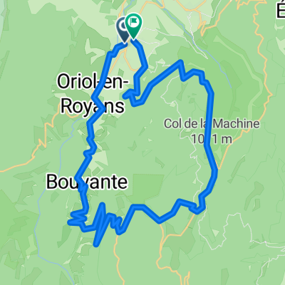
Overview
About this route
- 7 h 42 min
- Duration
- 63.3 km
- Distance
- 1,498 m
- Ascent
- 1,496 m
- Descent
- 8.2 km/h
- Avg. speed
- 1,199 m
- Max. altitude

Route photos


Route quality
Waytypes & surfaces along the route
Waytypes
Road
18.4 km
(29 %)
Quiet road
1.9 km
(3 %)
Surfaces
Paved
55.1 km
(87 %)
Asphalt
54.4 km
(86 %)
Concrete
0.6 km
(1 %)
Undefined
8.2 km
(13 %)
Continue with Bikemap
Use, edit, or download this cycling route
You would like to ride Avenue du Sert 2, Saint-Jean-en-Royans nach Avenue du Sert 4, Saint-Jean-en-Royans or customize it for your own trip? Here is what you can do with this Bikemap route:
Free features
- Save this route as favorite or in collections
- Copy & plan your own version of this route
- Sync your route with Garmin or Wahoo
Premium features
Free trial for 3 days, or one-time payment. More about Bikemap Premium.
- Navigate this route on iOS & Android
- Export a GPX / KML file of this route
- Create your custom printout (try it for free)
- Download this route for offline navigation
Discover more Premium features.
Get Bikemap PremiumFrom our community
Other popular routes starting in Saint-Jean-en-Royans
 Avenue du Sert 2, Saint-Jean-en-Royans nach Avenue du Sert 2, Saint-Jean-en-Royans
- Distance
- 77.4 km
- Ascent
- 2,019 m
- Descent
- 2,018 m
- Location
- Saint-Jean-en-Royans, Auvergne-Rhône-Alpes, France
 testers bliss
- Distance
- 27.6 km
- Ascent
- 294 m
- Descent
- 294 m
- Location
- Saint-Jean-en-Royans, Auvergne-Rhône-Alpes, France
 Combe Lavel Rundtour 50km
- Distance
- 41.5 km
- Ascent
- 1,613 m
- Descent
- 1,600 m
- Location
- Saint-Jean-en-Royans, Auvergne-Rhône-Alpes, France
 Parcours Vercors Saint Jean en Royans
- Distance
- 138 km
- Ascent
- 2,952 m
- Descent
- 2,955 m
- Location
- Saint-Jean-en-Royans, Auvergne-Rhône-Alpes, France
 FA14 St Jean-Heurieux
- Distance
- 122.7 km
- Ascent
- 952 m
- Descent
- 1,026 m
- Location
- Saint-Jean-en-Royans, Auvergne-Rhône-Alpes, France
 Combe Lavel Rundtour 50km
- Distance
- 37.8 km
- Ascent
- 1,821 m
- Descent
- 1,807 m
- Location
- Saint-Jean-en-Royans, Auvergne-Rhône-Alpes, France
 Col de Rousset Plus 10 More Vercors Cols from Bataille
- Distance
- 128.2 km
- Ascent
- 2,159 m
- Descent
- 2,169 m
- Location
- Saint-Jean-en-Royans, Auvergne-Rhône-Alpes, France
 Combe Lavel Rundtour 50km
- Distance
- 37.8 km
- Ascent
- 1,821 m
- Descent
- 1,807 m
- Location
- Saint-Jean-en-Royans, Auvergne-Rhône-Alpes, France
Open it in the app