

Limburgs mooiste gele lus zwaar 2011
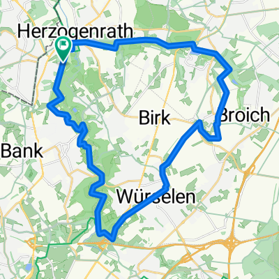
A cycling route starting in Herzogenrath, North Rhine-Westphalia, Germany.
Overview
About this route
<div style="background-image: initial; background-attachment: initial; background-origin: initial; background-clip: initial; background-color: #ffffff; color: #535353; font-family: Verdana, Arial, Helvetica, sans-serif; font-size: 10px; margin: 8px;">
Limburgs mooiste 110 km, gele lus 100 km zwaar 2011 </div>
- -:--
- Duration
- 100.4 km
- Distance
- 866 m
- Ascent
- 868 m
- Descent
- ---
- Avg. speed
- ---
- Max. altitude

Route quality
Waytypes & surfaces along the route
Waytypes
Quiet road
67.2 km
(67 %)
Road
16.7 km
(17 %)
Surfaces
Paved
88.4 km
(88 %)
Unpaved
0.5 km
(<1 %)
Asphalt
83.3 km
(83 %)
Paving stones
3.9 km
(4 %)
Continue with Bikemap
Use, edit, or download this cycling route
You would like to ride Limburgs mooiste gele lus zwaar 2011 or customize it for your own trip? Here is what you can do with this Bikemap route:
Free features
- Save this route as favorite or in collections
- Copy & plan your own version of this route
- Split it into stages to create a multi-day tour
- Sync your route with Garmin or Wahoo
Premium features
Free trial for 3 days, or one-time payment. More about Bikemap Premium.
- Navigate this route on iOS & Android
- Export a GPX / KML file of this route
- Create your custom printout (try it for free)
- Download this route for offline navigation
Discover more Premium features.
Get Bikemap PremiumFrom our community
Other popular routes starting in Herzogenrath
 rund um Kohlscheid
- Distance
- 36.9 km
- Ascent
- 192 m
- Descent
- 173 m
- Location
- Herzogenrath, North Rhine-Westphalia, Germany
 Tolle Landschaftsroute
- Distance
- 25.5 km
- Ascent
- 205 m
- Descent
- 222 m
- Location
- Herzogenrath, North Rhine-Westphalia, Germany
 Rund um den See
- Distance
- 40 km
- Ascent
- 127 m
- Descent
- 103 m
- Location
- Herzogenrath, North Rhine-Westphalia, Germany
 Brunsummer Heide Rodebach
- Distance
- 56 km
- Ascent
- 197 m
- Descent
- 218 m
- Location
- Herzogenrath, North Rhine-Westphalia, Germany
 Tolle Landschaftsroute CLONED FROM ROUTE 220895
- Distance
- 25.5 km
- Ascent
- 162 m
- Descent
- 162 m
- Location
- Herzogenrath, North Rhine-Westphalia, Germany
 AZAN Tour 4 Durch Den Norden Der Städteregion
- Distance
- 29.4 km
- Ascent
- 162 m
- Descent
- 163 m
- Location
- Herzogenrath, North Rhine-Westphalia, Germany
 An Wurm und Broichbach
- Distance
- 28.4 km
- Ascent
- 133 m
- Descent
- 111 m
- Location
- Herzogenrath, North Rhine-Westphalia, Germany
 Radler-Treff Richterich nach Valkenburg.
- Distance
- 40.6 km
- Ascent
- 151 m
- Descent
- 161 m
- Location
- Herzogenrath, North Rhine-Westphalia, Germany
Open it in the app