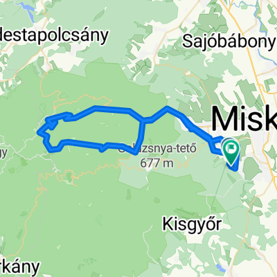
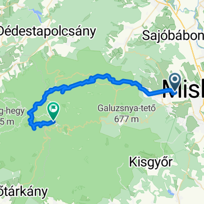
Miskolc - Lillafüred - Nagy-Mező - Olasz kapu - Szilvási kő - Bánkút - Felső-Borovnyák - Ómassa - Miskolc
A cycling route starting in Miskolc, Borsod-Abauj Zemplen county, Hungary.
Overview
About this route
- 7 h 51 min
- Duration
- 88.2 km
- Distance
- 1,827 m
- Ascent
- 1,827 m
- Descent
- 11.2 km/h
- Avg. speed
- 958 m
- Max. altitude
Route photos
Route quality
Waytypes & surfaces along the route
Waytypes
Quiet road
37.9 km
(43 %)
Track
17.6 km
(20 %)
Surfaces
Paved
58.2 km
(66 %)
Unpaved
21.2 km
(24 %)
Asphalt
58.2 km
(66 %)
Gravel
15.9 km
(18 %)
Continue with Bikemap
Use, edit, or download this cycling route
You would like to ride Miskolc - Lillafüred - Nagy-Mező - Olasz kapu - Szilvási kő - Bánkút - Felső-Borovnyák - Ómassa - Miskolc or customize it for your own trip? Here is what you can do with this Bikemap route:
Free features
- Save this route as favorite or in collections
- Copy & plan your own version of this route
- Split it into stages to create a multi-day tour
- Sync your route with Garmin or Wahoo
Premium features
Free trial for 3 days, or one-time payment. More about Bikemap Premium.
- Navigate this route on iOS & Android
- Export a GPX / KML file of this route
- Create your custom printout (try it for free)
- Download this route for offline navigation
Discover more Premium features.
Get Bikemap PremiumFrom our community
Other popular routes starting in Miskolc
- Könyves-Hámori tó (északi oldalon)
- Distance
- 11.7 km
- Ascent
- 294 m
- Descent
- 142 m
- Location
- Miskolc, Borsod-Abauj Zemplen county, Hungary
- KME - Déli Bükk II. 2016
- Distance
- 70.1 km
- Ascent
- 903 m
- Descent
- 900 m
- Location
- Miskolc, Borsod-Abauj Zemplen county, Hungary
- Miskolc-Nyéki tó (István tó)
- Distance
- 45.7 km
- Ascent
- 172 m
- Descent
- 187 m
- Location
- Miskolc, Borsod-Abauj Zemplen county, Hungary
- Miskolc - Lillafüred - Jávorkút - Nagy-mező- Bánkút - Bálvány hegy - Csipkéskút - Ómassa - Miskolc
- Distance
- 82.8 km
- Ascent
- 1,216 m
- Descent
- 1,215 m
- Location
- Miskolc, Borsod-Abauj Zemplen county, Hungary
- Miskolc - Lillafüred - Nagy-Mező - Olasz kapu - Szilvási kő - Bánkút - Felső-Borovnyák - Ómassa - Miskolc
- Distance
- 88.2 km
- Ascent
- 1,827 m
- Descent
- 1,827 m
- Location
- Miskolc, Borsod-Abauj Zemplen county, Hungary
- Miskolctapolca-Kisgyőr az év kerékpárútja jelölt
- Distance
- 67.5 km
- Ascent
- 748 m
- Descent
- 750 m
- Location
- Miskolc, Borsod-Abauj Zemplen county, Hungary
- Eger-miskolc erdei út
- Distance
- 65.8 km
- Ascent
- 757 m
- Descent
- 718 m
- Location
- Miskolc, Borsod-Abauj Zemplen county, Hungary
- Bringával a Bükk csúcsán 2013.
- Distance
- 61.6 km
- Ascent
- 890 m
- Descent
- 889 m
- Location
- Miskolc, Borsod-Abauj Zemplen county, Hungary
Open it in the app