

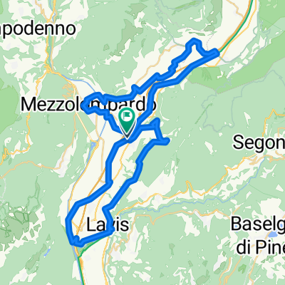
Da Via alle Ghiaie 56, San Michele all'Adige a Via alle Ghiaie 56, San Michele all'Adige
A cycling route starting in San Michele all'Adige, Trentino-Alto Adige, Italy.
Overview
About this route
- 5 h 5 min
- Duration
- 91.6 km
- Distance
- 546 m
- Ascent
- 547 m
- Descent
- 18.1 km/h
- Avg. speed
- 285 m
- Max. altitude

Route photos


Route quality
Waytypes & surfaces along the route
Waytypes
Cycleway
33.9 km
(37 %)
Quiet road
13.7 km
(15 %)
Surfaces
Paved
74.2 km
(81 %)
Unpaved
1.8 km
(2 %)
Asphalt
67.8 km
(74 %)
Paved (undefined)
6.4 km
(7 %)
Continue with Bikemap
Use, edit, or download this cycling route
You would like to ride Da Via alle Ghiaie 56, San Michele all'Adige a Via alle Ghiaie 56, San Michele all'Adige or customize it for your own trip? Here is what you can do with this Bikemap route:
Free features
- Save this route as favorite or in collections
- Copy & plan your own version of this route
- Split it into stages to create a multi-day tour
- Sync your route with Garmin or Wahoo
Premium features
Free trial for 3 days, or one-time payment. More about Bikemap Premium.
- Navigate this route on iOS & Android
- Export a GPX / KML file of this route
- Create your custom printout (try it for free)
- Download this route for offline navigation
Discover more Premium features.
Get Bikemap PremiumFrom our community
Other popular routes starting in San Michele all'Adige
 Percorso per Via Guglielmo Marconi
- Distance
- 99.4 km
- Ascent
- 2,122 m
- Descent
- 2,183 m
- Location
- San Michele all'Adige, Trentino-Alto Adige, Italy
 Giro del Vino 50
- Distance
- 54.7 km
- Ascent
- 793 m
- Descent
- 794 m
- Location
- San Michele all'Adige, Trentino-Alto Adige, Italy
 Giro del Vino 50 - Percorso SUD
- Distance
- 36.3 km
- Ascent
- 668 m
- Descent
- 666 m
- Location
- San Michele all'Adige, Trentino-Alto Adige, Italy
 Da Via alle Ghiaie 56, San Michele all'Adige a Via alle Ghiaie 56, San Michele all'Adige
- Distance
- 91.6 km
- Ascent
- 546 m
- Descent
- 547 m
- Location
- San Michele all'Adige, Trentino-Alto Adige, Italy
 San Michele - Lago Santo - Lavis
- Distance
- 44.3 km
- Ascent
- 1,570 m
- Descent
- 1,588 m
- Location
- San Michele all'Adige, Trentino-Alto Adige, Italy
 Hotel Cantaleone - Muse Trento
- Distance
- 36.7 km
- Ascent
- 102 m
- Descent
- 102 m
- Location
- San Michele all'Adige, Trentino-Alto Adige, Italy
 San Michele - Salurn - San Michele
- Distance
- 44.8 km
- Ascent
- 36 m
- Descent
- 37 m
- Location
- San Michele all'Adige, Trentino-Alto Adige, Italy
 San Michele all'Adige - Lago di Resia
- Distance
- 143.4 km
- Ascent
- 1,363 m
- Descent
- 53 m
- Location
- San Michele all'Adige, Trentino-Alto Adige, Italy
Open it in the app