Everett-LaConner-Whidbey Loop
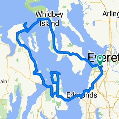
A cycling route starting in Mukilteo, Washington, United States.
Overview
About this route
The portion between Everett and LaConner is very flat, the rest is moderate hills. One could choose a more scenic backroad route thru Whidbey Island but it would add more miles and bigger hills. Don't miss the candy shop in LaConner. Get a good meal at the cafe in Silvana.
- -:--
- Duration
- 195.7 km
- Distance
- 727 m
- Ascent
- 726 m
- Descent
- ---
- Avg. speed
- ---
- Max. altitude
Route quality
Waytypes & surfaces along the route
Waytypes
Road
43.1 km
(22 %)
Quiet road
35.2 km
(18 %)
Surfaces
Paved
119.4 km
(61 %)
Asphalt
113.5 km
(58 %)
Paved (undefined)
3.9 km
(2 %)
Continue with Bikemap
Use, edit, or download this cycling route
You would like to ride Everett-LaConner-Whidbey Loop or customize it for your own trip? Here is what you can do with this Bikemap route:
Free features
- Save this route as favorite or in collections
- Copy & plan your own version of this route
- Split it into stages to create a multi-day tour
- Sync your route with Garmin or Wahoo
Premium features
Free trial for 3 days, or one-time payment. More about Bikemap Premium.
- Navigate this route on iOS & Android
- Export a GPX / KML file of this route
- Create your custom printout (try it for free)
- Download this route for offline navigation
Discover more Premium features.
Get Bikemap PremiumFrom our community
Other popular routes starting in Mukilteo
- Everett-Maple Valley 4 Trails
- Distance
- 174.4 km
- Ascent
- 458 m
- Descent
- 458 m
- Location
- Mukilteo, Washington, United States
- Everett-LaConner-Whidbey Loop
- Distance
- 195.7 km
- Ascent
- 727 m
- Descent
- 726 m
- Location
- Mukilteo, Washington, United States
- USA - Mukilteo: Pudget Sound Discovery Tour
- Distance
- 156.8 km
- Ascent
- 735 m
- Descent
- 735 m
- Location
- Mukilteo, Washington, United States
- EI to Marymoor
- Distance
- 40 km
- Ascent
- 115 m
- Descent
- 272 m
- Location
- Mukilteo, Washington, United States
- Everett to Lk Washington Loop
- Distance
- 132.8 km
- Ascent
- 643 m
- Descent
- 643 m
- Location
- Mukilteo, Washington, United States
- Everett to LaConner
- Distance
- 81.2 km
- Ascent
- 200 m
- Descent
- 318 m
- Location
- Mukilteo, Washington, United States
- Paine Field Area Hill Ride
- Distance
- 24.3 km
- Ascent
- 352 m
- Descent
- 349 m
- Location
- Mukilteo, Washington, United States
- Paine Field hill route.
- Distance
- 33.7 km
- Ascent
- 432 m
- Descent
- 432 m
- Location
- Mukilteo, Washington, United States
Open it in the app