

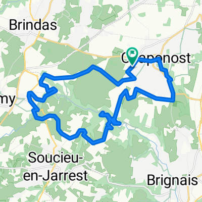
04892-1101-Chaponost-Thurins-Courzieu-Vaugneray-Brindas-Chaponost
A cycling route starting in Chaponost, Auvergne-Rhône-Alpes, France.
Overview
About this route
04892-1101-Chaponost-Thurins-Courzieu-Vaugneray-Brindas-Chaponost
- -:--
- Duration
- 47.1 km
- Distance
- 1,269 m
- Ascent
- 1,277 m
- Descent
- ---
- Avg. speed
- 826 m
- Max. altitude

Route quality
Waytypes & surfaces along the route
Waytypes
Road
27.1 km
(58 %)
Busy road
10.1 km
(21 %)
Surfaces
Paved
16.6 km
(35 %)
Unpaved
0.8 km
(2 %)
Asphalt
16.4 km
(35 %)
Ground
0.8 km
(2 %)
Continue with Bikemap
Use, edit, or download this cycling route
You would like to ride 04892-1101-Chaponost-Thurins-Courzieu-Vaugneray-Brindas-Chaponost or customize it for your own trip? Here is what you can do with this Bikemap route:
Free features
- Save this route as favorite or in collections
- Copy & plan your own version of this route
- Sync your route with Garmin or Wahoo
Premium features
Free trial for 3 days, or one-time payment. More about Bikemap Premium.
- Navigate this route on iOS & Android
- Export a GPX / KML file of this route
- Create your custom printout (try it for free)
- Download this route for offline navigation
Discover more Premium features.
Get Bikemap PremiumFrom our community
Other popular routes starting in Chaponost
 Route de Brignais, Saint-Genis-Laval à Avenue Guy-de-Collongue, Écully
- Distance
- 12.9 km
- Ascent
- 207 m
- Descent
- 167 m
- Location
- Chaponost, Auvergne-Rhône-Alpes, France
 Col des brosses (malval et luere)
- Distance
- 51.4 km
- Ascent
- 773 m
- Descent
- 773 m
- Location
- Chaponost, Auvergne-Rhône-Alpes, France
 05319-0825-Chaponost-Brindas-LaTourDeSalvagny-SteConsorce-StLaurentDeVaux-Messimy-Brindas-Chaponost
- Distance
- 51.8 km
- Ascent
- 881 m
- Descent
- 782 m
- Location
- Chaponost, Auvergne-Rhône-Alpes, France
 04892-1101-Chaponost-Thurins-Courzieu-Vaugneray-Brindas-Chaponost
- Distance
- 47.1 km
- Ascent
- 1,269 m
- Descent
- 1,277 m
- Location
- Chaponost, Auvergne-Rhône-Alpes, France
 Chaponost - Parcours sportif du soir - 26384 - UtagawaVTT.com
- Distance
- 18.8 km
- Ascent
- 340 m
- Descent
- 340 m
- Location
- Chaponost, Auvergne-Rhône-Alpes, France
 Tour Chaponost Yzeron
- Distance
- 47.7 km
- Ascent
- 984 m
- Descent
- 981 m
- Location
- Chaponost, Auvergne-Rhône-Alpes, France
 De 20 Avenue Paul Doumer, Chaponost à 46 Chemin de la Lande, Brignais
- Distance
- 3.6 km
- Ascent
- 13 m
- Descent
- 85 m
- Location
- Chaponost, Auvergne-Rhône-Alpes, France
 De 2 Boulevard du Général de Gaulle, Chaponost à 2 Boulevard du Général de Gaulle, Chaponost
- Distance
- 20.1 km
- Ascent
- 395 m
- Descent
- 391 m
- Location
- Chaponost, Auvergne-Rhône-Alpes, France
Open it in the app