

Big Rivers, Pilot Knob, Acadia, Valley Park, ...
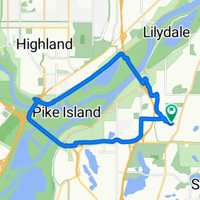
A cycling route starting in Mendota Heights, Minnesota, United States.
Overview
About this route
Lilydale Road
Big Rivers Regional Trail
Pilot Knob Road
Acacia Blvd
13
Centre Point Curve
Lexington Ave S
Marie Ave W
Valley Park [Regional Trail?] - with a mistake :-)
Lilydale Road
- -:--
- Duration
- 13.3 km
- Distance
- 206 m
- Ascent
- 206 m
- Descent
- ---
- Avg. speed
- ---
- Max. altitude
Route quality
Waytypes & surfaces along the route
Waytypes
Cycleway
13.3 km
(100 %)
Access road
0 km
(<1 %)
Surfaces
Paved
13.3 km
(100 %)
Asphalt
8.1 km
(61 %)
Paved (undefined)
5.2 km
(39 %)
Undefined
0 km
(<1 %)
Continue with Bikemap
Use, edit, or download this cycling route
You would like to ride Big Rivers, Pilot Knob, Acadia, Valley Park, ... or customize it for your own trip? Here is what you can do with this Bikemap route:
Free features
- Save this route as favorite or in collections
- Copy & plan your own version of this route
- Sync your route with Garmin or Wahoo
Premium features
Free trial for 3 days, or one-time payment. More about Bikemap Premium.
- Navigate this route on iOS & Android
- Export a GPX / KML file of this route
- Create your custom printout (try it for free)
- Download this route for offline navigation
Discover more Premium features.
Get Bikemap PremiumFrom our community
Other popular routes starting in Mendota Heights
 Big Rivers, Pilot Knob, Acadia, Valley Park, ...
- Distance
- 13.3 km
- Ascent
- 206 m
- Descent
- 206 m
- Location
- Mendota Heights, Minnesota, United States
 B2B00914 55116>55435 via Mend Brg, 494 bike brg, 73rd
- Distance
- 22.6 km
- Ascent
- 141 m
- Descent
- 132 m
- Location
- Mendota Heights, Minnesota, United States
 Snail-like route in Mendota Heights
- Distance
- 14 km
- Ascent
- 325 m
- Descent
- 325 m
- Location
- Mendota Heights, Minnesota, United States
 River Loop
- Distance
- 15.5 km
- Ascent
- 99 m
- Descent
- 98 m
- Location
- Mendota Heights, Minnesota, United States
 Mendota Heights-South St.Paul
- Distance
- 35.7 km
- Ascent
- 218 m
- Descent
- 218 m
- Location
- Mendota Heights, Minnesota, United States
 B2B00191 55115>55401viaRandolph/MissBlvd/LkStBridge/WRiverPkwy/WashAv
- Distance
- 11.6 km
- Ascent
- 97 m
- Descent
- 109 m
- Location
- Mendota Heights, Minnesota, United States
 Fort Snelling Loop
- Distance
- 33.8 km
- Ascent
- 162 m
- Descent
- 164 m
- Location
- Mendota Heights, Minnesota, United States
 B2B00870 55116>55343 via MississippiRvBlvd/LakeStBridge/W.RiverRd/Greenway/Blake/Excel
- Distance
- 21.2 km
- Ascent
- 114 m
- Descent
- 96 m
- Location
- Mendota Heights, Minnesota, United States
Open it in the app