

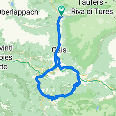
Sand-MariaSaalen-St.Vigil-Furkelpass-Olang-Sand
A cycling route starting in Sand in Taufers, Trentino-Alto Adige, Italy.
Overview
About this route
Elevation: approx. 1,400
Highest point: Furkelpass 1,789 meters
From Sand in Taufers, the first 20 km are flat to St. Lorenzen. From there, through Maria Saalen on a little-used asphalt road until just before St. Vigil, where you turn left at the intersection and it gets quite steep up to the Furkelpass.
At the Furkelpass, the descent to Olang begins, from there continuing on the bike path to Percha and through Dietenheim and Aufhofen to Gais. Then back along the bike path to Sand in Taufers.
- -:--
- Duration
- 72.3 km
- Distance
- 1,117 m
- Ascent
- 1,117 m
- Descent
- ---
- Avg. speed
- ---
- Max. altitude
Route quality
Waytypes & surfaces along the route
Waytypes
Road
16.6 km
(23 %)
Quiet road
6.5 km
(9 %)
Surfaces
Paved
45.6 km
(63 %)
Unpaved
2.2 km
(3 %)
Asphalt
45.6 km
(63 %)
Ground
2.2 km
(3 %)
Undefined
24.6 km
(34 %)
Continue with Bikemap
Use, edit, or download this cycling route
You would like to ride Sand-MariaSaalen-St.Vigil-Furkelpass-Olang-Sand or customize it for your own trip? Here is what you can do with this Bikemap route:
Free features
- Save this route as favorite or in collections
- Copy & plan your own version of this route
- Sync your route with Garmin or Wahoo
Premium features
Free trial for 3 days, or one-time payment. More about Bikemap Premium.
- Navigate this route on iOS & Android
- Export a GPX / KML file of this route
- Create your custom printout (try it for free)
- Download this route for offline navigation
Discover more Premium features.
Get Bikemap PremiumFrom our community
Other popular routes starting in Sand in Taufers
 Sand in Taufers - Acereto
- Distance
- 6.8 km
- Ascent
- 477 m
- Descent
- 27 m
- Location
- Sand in Taufers, Trentino-Alto Adige, Italy
 Blossberg
- Distance
- 19.4 km
- Ascent
- 1,756 m
- Descent
- 73 m
- Location
- Sand in Taufers, Trentino-Alto Adige, Italy
 Sand-MariaSaalen-St.Vigil-Furkelpass-Olang-Sand
- Distance
- 72.3 km
- Ascent
- 1,117 m
- Descent
- 1,117 m
- Location
- Sand in Taufers, Trentino-Alto Adige, Italy
 Sand-Luttach-Weissenbach-Großstahlhof
- Distance
- 20.4 km
- Ascent
- 474 m
- Descent
- 474 m
- Location
- Sand in Taufers, Trentino-Alto Adige, Italy
 Un passo dal Cielo-Agosto 2021-Valle Aurina, Dobbiaco
- Distance
- 51.4 km
- Ascent
- 474 m
- Descent
- 224 m
- Location
- Sand in Taufers, Trentino-Alto Adige, Italy
 Malga Gruber
- Distance
- 21.5 km
- Ascent
- 873 m
- Descent
- 868 m
- Location
- Sand in Taufers, Trentino-Alto Adige, Italy
 Sand in Taufers - Bruneck
- Distance
- 16.2 km
- Ascent
- 38 m
- Descent
- 79 m
- Location
- Sand in Taufers, Trentino-Alto Adige, Italy
 a-high-mountain-route-in-the-natural-park-rieserfern-ahr - proposed
- Distance
- 93.1 km
- Ascent
- 1,872 m
- Descent
- 1,874 m
- Location
- Sand in Taufers, Trentino-Alto Adige, Italy
Open it in the app