

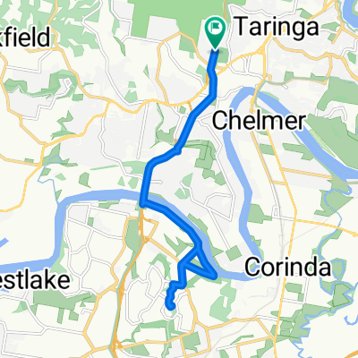
Mt Cootha Loop
A cycling route starting in Taringa, Queensland, Australia.
Overview
About this route
Tougher than first tought
- -:--
- Duration
- 9.6 km
- Distance
- 261 m
- Ascent
- 261 m
- Descent
- ---
- Avg. speed
- ---
- Max. altitude

Continue with Bikemap
Use, edit, or download this cycling route
You would like to ride Mt Cootha Loop or customize it for your own trip? Here is what you can do with this Bikemap route:
Free features
- Save this route as favorite or in collections
- Copy & plan your own version of this route
- Sync your route with Garmin or Wahoo
Premium features
Free trial for 3 days, or one-time payment. More about Bikemap Premium.
- Navigate this route on iOS & Android
- Export a GPX / KML file of this route
- Create your custom printout (try it for free)
- Download this route for offline navigation
Discover more Premium features.
Get Bikemap PremiumFrom our community
Other popular routes starting in Taringa
 Mt Cootha finish with breakfast
- Distance
- 5.9 km
- Ascent
- 268 m
- Descent
- 272 m
- Location
- Taringa, Queensland, Australia
 3 figures route
- Distance
- 67.9 km
- Ascent
- 449 m
- Descent
- 453 m
- Location
- Taringa, Queensland, Australia
 Western Brisbane 67 km River Loop
- Distance
- 67.3 km
- Ascent
- 759 m
- Descent
- 758 m
- Location
- Taringa, Queensland, Australia
 28 Ada Street, Toowong to 30 Ada Street, Toowong
- Distance
- 10.9 km
- Ascent
- 0 m
- Descent
- 10 m
- Location
- Taringa, Queensland, Australia
 Toowong, Mt Mee, Samford, Mt Nebo loop
- Distance
- 165.9 km
- Ascent
- 1,274 m
- Descent
- 1,271 m
- Location
- Taringa, Queensland, Australia
 Rover Bike Night
- Distance
- 17.4 km
- Ascent
- 197 m
- Descent
- 199 m
- Location
- Taringa, Queensland, Australia
 Nebo Samford Dayboro
- Distance
- 117 km
- Ascent
- 862 m
- Descent
- 859 m
- Location
- Taringa, Queensland, Australia
 River Loop: Jindalee-Teneriffe
- Distance
- 35.4 km
- Ascent
- 179 m
- Descent
- 179 m
- Location
- Taringa, Queensland, Australia
Open it in the app