

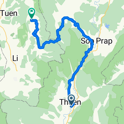
ทางหลวงชนบท ลป.3021 135, ตำบล นาโป่ง to ทางหลวงชนบท ลป.3021 135, ตำบล นาโป่ง
A cycling route starting in Thoen, Lampang, Thailand.
Overview
About this route
- 26 min
- Duration
- 12 km
- Distance
- 172 m
- Ascent
- 171 m
- Descent
- 27.4 km/h
- Avg. speed
- 221 m
- Max. altitude

Route photos


Continue with Bikemap
Use, edit, or download this cycling route
You would like to ride ทางหลวงชนบท ลป.3021 135, ตำบล นาโป่ง to ทางหลวงชนบท ลป.3021 135, ตำบล นาโป่ง or customize it for your own trip? Here is what you can do with this Bikemap route:
Free features
- Save this route as favorite or in collections
- Copy & plan your own version of this route
- Sync your route with Garmin or Wahoo
Premium features
Free trial for 3 days, or one-time payment. More about Bikemap Premium.
- Navigate this route on iOS & Android
- Export a GPX / KML file of this route
- Create your custom printout (try it for free)
- Download this route for offline navigation
Discover more Premium features.
Get Bikemap PremiumFrom our community
Other popular routes starting in Thoen
 Thailand Tour Stage #7 Amphoe Thoen, Lampang - Sukhothai
- Distance
- 120.7 km
- Ascent
- 287 m
- Descent
- 407 m
- Location
- Thoen, Lampang, Thailand
 ทางหลวงชนบท ลป.3021 135, ตำบล นาโป่ง to ทางหลวงชนบท ลป.3021 135, ตำบล นาโป่ง
- Distance
- 12 km
- Ascent
- 172 m
- Descent
- 171 m
- Location
- Thoen, Lampang, Thailand
 ทางหลวงชนบท ลป.3021, ตำบล นาโป่ง to ทางหลวงชนบท ลป.3021, ตำบล นาโป่ง
- Distance
- 18.9 km
- Ascent
- 81 m
- Descent
- 83 m
- Location
- Thoen, Lampang, Thailand
 Dag12 Thoen- Bang Wang Din 53km
- Distance
- 53.2 km
- Ascent
- 926 m
- Descent
- 641 m
- Location
- Thoen, Lampang, Thailand
 9 From Thoen to Thung Hua Chang
- Distance
- 115.1 km
- Ascent
- 1,499 m
- Descent
- 1,105 m
- Location
- Thoen, Lampang, Thailand
 chiang mai tag 5
- Distance
- 60.9 km
- Ascent
- 345 m
- Descent
- 414 m
- Location
- Thoen, Lampang, Thailand
 Chiang Mai - Uttaradit via Satchanalai
- Distance
- 152.5 km
- Ascent
- 355 m
- Descent
- 462 m
- Location
- Thoen, Lampang, Thailand
 Thailand Tour Stage #12 Thoen - Pa Phlu 100Km 900Hm
- Distance
- 106.5 km
- Ascent
- 1,280 m
- Descent
- 1,082 m
- Location
- Thoen, Lampang, Thailand
Open it in the app