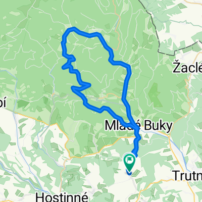
Trutnov-Vlčice - Jelenka - Pomezky - Karpacz - Špindlerovka - Strážné - Hostinné - Vlčice
- 127.4 km
- 2,124 m
- 2,124 m
- Pilníkov, Královéhradecký kraj, Czechia
A cycling route starting in Pilníkov, Královéhradecký kraj, Czechia.
Overview
A more challenging 130 km circular route in the Krkonoše Mountains with 2,650 meters of elevation gain, crossing the Krkonoše ridge twice. The route is mainly on asphalt roads, partly on well-compacted gravel roads, with only some sections having larger stones. The route is primarily suitable for trekking bikes.
The start and end of the route are in the village of Vlčice, west of Trutnov. From Vlčice we ascend to Hrádeček and descend to Mladé Buky, then continue to Svoboda nad Úpou via Horní Maršov. At the crossroads beyond Temný Důl we turn right onto road no. 252 and ascend to Horní Malá Úpa. At its beginning we turn left onto a narrow asphalt road and follow the yellow tourist trail descending to the Pod Jelenkou junction, from where we sharply climb on a good road and the yellow trail up to Na Jelenku (1,260 m a.s.l.). Here there is an option to refresh. We ride back a few meters, then turn left onto the red tourist trail, an unpaved but well-ridable path. With due caution we descend to the tourist crossing into Poland at Soví sedlo, continue straight, ascend from the saddle and follow the red trail along the ridge, where the road is again well compacted, and descend to Pomezní Boudy, where refreshments are again available.
We cross the state border into Poland and descend the road to a crossroads where we turn left onto a compacted gravel road and descend into the town of Kowary, then turn left onto road no. 366 and head left to Karpacz. We ascend through the town to the turnoff to the Wang church and up to Sněžka. Here you can have lunch at one of the good local restaurants.
We descend from the town to the junction by the bridge and turn sharply left, ascending past the village of Borowice and then along the road through the forest. About 50 meters left from the road in the forest stands a mushroom-shaped monument to the many victims of World War II. We continue the ascent to a parking area with a crossroads. It is advisable to rest a bit here before the next climb. We turn left and on a good road we climb steep and long to the ridge at 1,200 m, crossing the state border back to the Czech Republic, with refreshment available in Špindlerův Mlýn.
From Špindlerův Mlýn we descend the road into Špindlerův Mlýn and then along the Elbe river down to Vrchlabí. At the town's start we turn left and climb to Strážné, descend to Lánov, cross road no. 14 to Dolní Lánov, there turn left on C4299 and at the hill junction turn right to Fořt and then right to Hostinné. After the bridge we turn left and ascend along C4300, over the ridge to Čermná, then down the valley crossing the road and continuing along C4300, and on the hill straight ahead on a gravel road across the fields back to Vlčice. At the junction we turn left and ride to the route's starting point where the tour ends.
created this 14 years ago
Route quality
Road
36.9 km
(29 %)
Track
28 km
(22 %)
Paved
63.7 km
(50 %)
Unpaved
15.3 km
(12 %)
Asphalt
58.6 km
(46 %)
Ground
6.4 km
(5 %)
Continue with Bikemap
You would like to ride Trutnov-Vlčice - Jelenka - Pomezky - Karpacz - Špindlerovka - Strážné - Hostinné - Vlčice or customize it for your own trip? Here is what you can do with this Bikemap route:
Free trial for 3 days, or one-time payment. More about Bikemap Premium.
Discover more Premium features.
Get Bikemap PremiumFrom our community
Open it in the app