

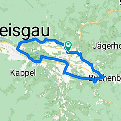
attental-st.peter = kurze knackige trainingsstrecke
A cycling route starting in Stegen, Baden-Wurttemberg, Germany.
Overview
About this route
route: attental-stegen-ibental-st.peter-eschbach-stegen (approx. 26 km)
starting point attental/municipality of stegen --> direction stegen (there is a short section here - krotzingerweg/main road - which may not be good to ride on a road bike, as it is a gravel road. however, it can be avoided via l 133. the rest of the route is absolutely suitable for road bikes!) from stegen, it goes gently uphill to ibental via oberbirken. while traveling the length of ibental, the continuous ascent to st.peter begins at the end of the valley. especially the last 2 km are quite challenging and steep. upon arriving at st.peter, one goes right through the village, passing the church square, down the already mentioned l 133 back into the valley towards eschbach. from eschbach, it levels out again.
conclusion: a relatively short, but definitely very challenging route with training character.
- -:--
- Duration
- 25.7 km
- Distance
- 629 m
- Ascent
- 600 m
- Descent
- ---
- Avg. speed
- 726 m
- Max. altitude

Route quality
Waytypes & surfaces along the route
Waytypes
Quiet road
9 km
(35 %)
Path
4.4 km
(17 %)
Surfaces
Paved
21.8 km
(85 %)
Unpaved
3.1 km
(12 %)
Asphalt
20.6 km
(80 %)
Gravel
2.3 km
(9 %)
Continue with Bikemap
Use, edit, or download this cycling route
You would like to ride attental-st.peter = kurze knackige trainingsstrecke or customize it for your own trip? Here is what you can do with this Bikemap route:
Free features
- Save this route as favorite or in collections
- Copy & plan your own version of this route
- Sync your route with Garmin or Wahoo
Premium features
Free trial for 3 days, or one-time payment. More about Bikemap Premium.
- Navigate this route on iOS & Android
- Export a GPX / KML file of this route
- Create your custom printout (try it for free)
- Download this route for offline navigation
Discover more Premium features.
Get Bikemap PremiumFrom our community
Other popular routes starting in Stegen
 attental-st.peter/platte = anspruchsvoller anstieg
- Distance
- 37.6 km
- Ascent
- 1,011 m
- Descent
- 963 m
- Location
- Stegen, Baden-Wurttemberg, Germany
 ebnet-windräder
- Distance
- 8.6 km
- Ascent
- 579 m
- Descent
- 292 m
- Location
- Stegen, Baden-Wurttemberg, Germany
 Schulstiftungs-Brevet
- Distance
- 626.4 km
- Ascent
- 2,071 m
- Descent
- 2,071 m
- Location
- Stegen, Baden-Wurttemberg, Germany
 attental-st.peter = kurze knackige trainingsstrecke
- Distance
- 25.7 km
- Ascent
- 629 m
- Descent
- 600 m
- Location
- Stegen, Baden-Wurttemberg, Germany
 Stegen-Buchenbach-Ebnet
- Distance
- 20.2 km
- Ascent
- 152 m
- Descent
- 152 m
- Location
- Stegen, Baden-Wurttemberg, Germany
 Stegen - Schauinsland - Stegen
- Distance
- 44.7 km
- Ascent
- 946 m
- Descent
- 944 m
- Location
- Stegen, Baden-Wurttemberg, Germany
 Kandelkönig am 25.7.2015
- Distance
- 60.5 km
- Ascent
- 1,292 m
- Descent
- 1,293 m
- Location
- Stegen, Baden-Wurttemberg, Germany
 attental-kandel = mittelschwere bergetappe im südschwarzwald
- Distance
- 87.2 km
- Ascent
- 2,197 m
- Descent
- 1,919 m
- Location
- Stegen, Baden-Wurttemberg, Germany
Open it in the app