

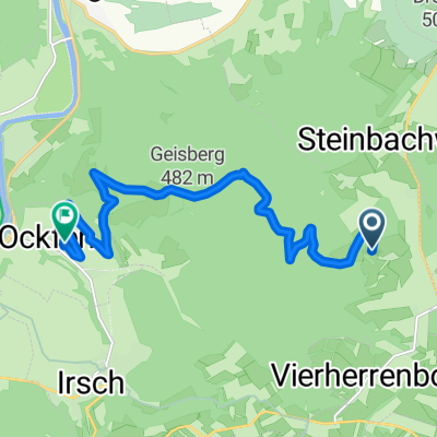
Vierherrenborn nach ockfen
A cycling route starting in Baldringen, Rhineland-Palatinate, Germany.
Overview
About this route
- -:--
- Duration
- 5.9 km
- Distance
- 0 m
- Ascent
- 256 m
- Descent
- ---
- Avg. speed
- 452 m
- Max. altitude
Route quality
Waytypes & surfaces along the route
Waytypes
Track
5.5 km
(94 %)
Road
0.2 km
(4 %)
Surfaces
Paved
1.2 km
(20 %)
Unpaved
4.6 km
(78 %)
Unpaved (undefined)
2.3 km
(39 %)
Loose gravel
1.9 km
(32 %)
Continue with Bikemap
Use, edit, or download this cycling route
You would like to ride Vierherrenborn nach ockfen or customize it for your own trip? Here is what you can do with this Bikemap route:
Free features
- Save this route as favorite or in collections
- Copy & plan your own version of this route
- Sync your route with Garmin or Wahoo
Premium features
Free trial for 3 days, or one-time payment. More about Bikemap Premium.
- Navigate this route on iOS & Android
- Export a GPX / KML file of this route
- Create your custom printout (try it for free)
- Download this route for offline navigation
Discover more Premium features.
Get Bikemap PremiumFrom our community
Other popular routes starting in Baldringen
 Baldringen-Ruwer-Hochwald Schleife
- Distance
- 12.8 km
- Ascent
- 375 m
- Descent
- 380 m
- Location
- Baldringen, Rhineland-Palatinate, Germany
 Am Steinbruch 2, Baldringen nach Karthäuser Straße 3, Konz
- Distance
- 21.8 km
- Ascent
- 198 m
- Descent
- 509 m
- Location
- Baldringen, Rhineland-Palatinate, Germany
 Vierherrenborn nach ockfen
- Distance
- 5.9 km
- Ascent
- 0 m
- Descent
- 256 m
- Location
- Baldringen, Rhineland-Palatinate, Germany
 Am Steinbruch 2, Baldringen nach Karthäuser Straße 3, Konz
- Distance
- 18.5 km
- Ascent
- 125 m
- Descent
- 438 m
- Location
- Baldringen, Rhineland-Palatinate, Germany
 Baldringen - Loebstraße Trier
- Distance
- 46.8 km
- Ascent
- 578 m
- Descent
- 570 m
- Location
- Baldringen, Rhineland-Palatinate, Germany
 Römerstraße, Vierherrenborn nach Weinbergstraße, Ockfen
- Distance
- 12 km
- Ascent
- 147 m
- Descent
- 436 m
- Location
- Baldringen, Rhineland-Palatinate, Germany
 Hentern Wandern
- Distance
- 21.1 km
- Ascent
- 339 m
- Descent
- 357 m
- Location
- Baldringen, Rhineland-Palatinate, Germany
 Am Steinbruch 2, Baldringen nach Karthäuser Straße 3, Konz
- Distance
- 21.9 km
- Ascent
- 198 m
- Descent
- 509 m
- Location
- Baldringen, Rhineland-Palatinate, Germany
Open it in the app