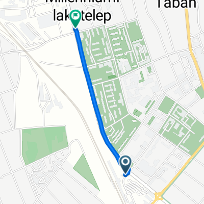
OKKT 04
A cycling route starting in Békéscsaba, Bekes County, Hungary.
Overview
About this route
Békéscsaba - Balatonföldvár
- -:--
- Duration
- 721.7 km
- Distance
- 2,034 m
- Ascent
- 2,015 m
- Descent
- ---
- Avg. speed
- 261 m
- Max. altitude
Route photos
Route quality
Waytypes & surfaces along the route
Waytypes
Quiet road
115.5 km
(16 %)
Cycleway
115.5 km
(16 %)
Surfaces
Paved
375.3 km
(52 %)
Unpaved
7.2 km
(1 %)
Asphalt
360.8 km
(50 %)
Concrete
14.4 km
(2 %)
Continue with Bikemap
Use, edit, or download this cycling route
You would like to ride OKKT 04 or customize it for your own trip? Here is what you can do with this Bikemap route:
Free features
- Save this route as favorite or in collections
- Copy & plan your own version of this route
- Split it into stages to create a multi-day tour
- Sync your route with Garmin or Wahoo
Premium features
Free trial for 3 days, or one-time payment. More about Bikemap Premium.
- Navigate this route on iOS & Android
- Export a GPX / KML file of this route
- Create your custom printout (try it for free)
- Download this route for offline navigation
Discover more Premium features.
Get Bikemap PremiumFrom our community
Other popular routes starting in Békéscsaba
- Kolozsvári utca 79., Békéscsaba - Kolozsvári utca 79., Békéscsaba
- Distance
- 50.7 km
- Ascent
- 171 m
- Descent
- 170 m
- Location
- Békéscsaba, Bekes County, Hungary
- 001 - 100km-es országúti edzőkör
- Distance
- 96.6 km
- Ascent
- 13 m
- Descent
- 16 m
- Location
- Békéscsaba, Bekes County, Hungary
- Föld napi kerékpár túra, (Papp Attila módra) 2011. szeptember 24.
- Distance
- 142.2 km
- Ascent
- 23 m
- Descent
- 23 m
- Location
- Békéscsaba, Bekes County, Hungary
- 2018 Fléche
- Distance
- 375 km
- Ascent
- 391 m
- Descent
- 342 m
- Location
- Békéscsaba, Bekes County, Hungary
- Pataky László utca 17., Békéscsaba - Kolozsvári utca 79., Békéscsaba
- Distance
- 26.9 km
- Ascent
- 112 m
- Descent
- 113 m
- Location
- Békéscsaba, Bekes County, Hungary
- Kolozsvári utca 79., Békéscsaba - Kolozsvári utca 79., Békéscsaba
- Distance
- 43.4 km
- Ascent
- 154 m
- Descent
- 162 m
- Location
- Békéscsaba, Bekes County, Hungary
- Wenckheim - Szabadkígyós kerékpárút
- Distance
- 10.9 km
- Ascent
- 8 m
- Descent
- 8 m
- Location
- Békéscsaba, Bekes County, Hungary
- Wenckheim - Póstelek - Gerla kerékpárút
- Distance
- 19.7 km
- Ascent
- 32 m
- Descent
- 36 m
- Location
- Békéscsaba, Bekes County, Hungary
Open it in the app