

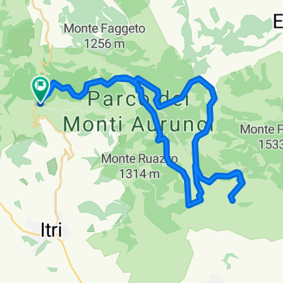
Campodimele - S.Onofrio - Valle Vona - Pico
A cycling route starting in Campodimele, Latium, Italy.
Overview
About this route
GUIDA AI PERCORSI IN MOUNTAINBIKE nel Parco Naturale dei Monti Aurunci
Percorso n°14
Percorso ad anello per mountainbike su fondo in gran parte asfaltato, relativamente impegnativo è accessibile a tutti ipraticanti della mountainbike.
(Il percorso segnalato è esemplificativo, informazioni ulteriori nella Guida ai Percorsi in Mountainbike nel Parco Naturale dei Monti).
- -:--
- Duration
- 28.3 km
- Distance
- 697 m
- Ascent
- 829 m
- Descent
- ---
- Avg. speed
- 730 m
- Avg. speed

Route quality
Waytypes & surfaces along the route
Waytypes
Busy road
11.1 km
(39 %)
Quiet road
8.9 km
(31 %)
Surfaces
Unpaved
3.9 km
(14 %)
Ground
1.5 km
(5 %)
Gravel
1.2 km
(4 %)
Route highlights
Points of interest along the route

Point of interest after 28 km
Maggiori informazioni nella Guida ai Percorsi In Mountainbike nel Parco naturale dei Monti Aurunci
Continue with Bikemap
Use, edit, or download this cycling route
You would like to ride Campodimele - S.Onofrio - Valle Vona - Pico or customize it for your own trip? Here is what you can do with this Bikemap route:
Free features
- Save this route as favorite or in collections
- Copy & plan your own version of this route
- Sync your route with Garmin or Wahoo
Premium features
Free trial for 3 days, or one-time payment. More about Bikemap Premium.
- Navigate this route on iOS & Android
- Export a GPX / KML file of this route
- Create your custom printout (try it for free)
- Download this route for offline navigation
Discover more Premium features.
Get Bikemap PremiumFrom our community
Other popular routes starting in Campodimele
 enduro 3
- Distance
- 1.6 km
- Ascent
- 30 m
- Descent
- 387 m
- Location
- Campodimele, Latium, Italy
 wodpark redentore
- Distance
- 44.8 km
- Ascent
- 1,260 m
- Descent
- 1,262 m
- Location
- Campodimele, Latium, Italy
 Rifugio di Monte Faggeto - Convento di S. onofrio
- Distance
- 21.1 km
- Ascent
- 799 m
- Descent
- 809 m
- Location
- Campodimele, Latium, Italy
 Campodimele - S.Onofrio - Valle Vona - Pico
- Distance
- 28.3 km
- Ascent
- 697 m
- Descent
- 829 m
- Location
- Campodimele, Latium, Italy
 enduro 2
- Distance
- 2.6 km
- Ascent
- 93 m
- Descent
- 450 m
- Location
- Campodimele, Latium, Italy
 Da Unnamed Road, Campodimele a Via Gianola 8, Formia
- Distance
- 34.7 km
- Ascent
- 437 m
- Descent
- 817 m
- Location
- Campodimele, Latium, Italy
 S. Nicola - Piana di Campello - Valle Trasta
- Distance
- 19.8 km
- Ascent
- 632 m
- Descent
- 624 m
- Location
- Campodimele, Latium, Italy
 2° giorno: Campodimele - Esperia
- Distance
- 60.6 km
- Ascent
- 1,475 m
- Descent
- 1,484 m
- Location
- Campodimele, Latium, Italy
Open it in the app