

Bergzeitfahren Ehrenzipfel-Brandberg
A cycling route starting in Rittersgrün, Saxony, Germany.
Overview
About this route
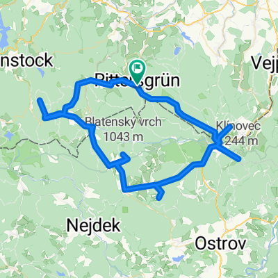
Bergzeitfahren Ehrenzipfel - Brandberg
- -:--
- Duration
- 9 km
- Distance
- 482 m
- Ascent
- 81 m
- Descent
- ---
- Avg. speed
- ---
- Max. altitude
Continue with Bikemap
Use, edit, or download this cycling route
You would like to ride Bergzeitfahren Ehrenzipfel-Brandberg or customize it for your own trip? Here is what you can do with this Bikemap route:
Free features
- Save this route as favorite or in collections
- Copy & plan your own version of this route
- Sync your route with Garmin or Wahoo
Premium features
Free trial for 3 days, or one-time payment. More about Bikemap Premium.
- Navigate this route on iOS & Android
- Export a GPX / KML file of this route
- Create your custom printout (try it for free)
- Download this route for offline navigation
Discover more Premium features.
Get Bikemap PremiumFrom our community
Other popular routes starting in Rittersgrün
 SMQ MTB C-Edition Umleitung Drückjagd Rittersgrün-Fichtelberg 09.10.2021
- Distance
- 16 km
- Ascent
- 689 m
- Descent
- 135 m
- Location
- Rittersgrün, Saxony, Germany
 Bergzeitfahren Ehrenzipfel-Brandberg
- Distance
- 9 km
- Ascent
- 482 m
- Descent
- 81 m
- Location
- Rittersgrün, Saxony, Germany
 Fünf 1000er Erzgebirge
- Distance
- 82.7 km
- Ascent
- 1,521 m
- Descent
- 1,521 m
- Location
- Rittersgrün, Saxony, Germany
 Roter Fuchs
- Distance
- 13.4 km
- Ascent
- 394 m
- Descent
- 397 m
- Location
- Rittersgrün, Saxony, Germany
 R - Schlettau - Preßnitztal - Jöhstadt - Medenec - Bozi Dar - R
- Distance
- 108.6 km
- Ascent
- 1,081 m
- Descent
- 1,081 m
- Location
- Rittersgrün, Saxony, Germany
 Käserei CZ
- Distance
- 25.7 km
- Ascent
- 409 m
- Descent
- 409 m
- Location
- Rittersgrün, Saxony, Germany
 002_Rittersgrün-Waschleithe-Geyer-Crottendorf-Raschau-Rittersgrün
- Distance
- 66.4 km
- Ascent
- 722 m
- Descent
- 722 m
- Location
- Rittersgrün, Saxony, Germany
 Zollstraße 4, Breitenbrunn/Erzgebirge nach Zollstraße 4, Breitenbrunn/Erzgebirge
- Distance
- 23.5 km
- Ascent
- 155 m
- Descent
- 155 m
- Location
- Rittersgrün, Saxony, Germany
Open it in the app