

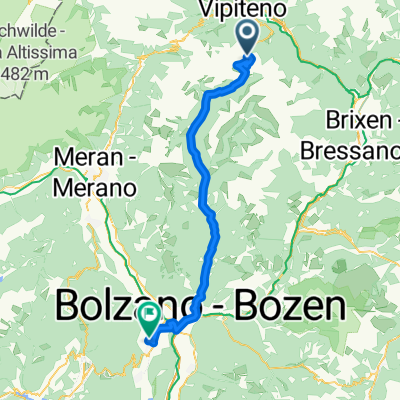
Mauls - Toblach M-V 22
A cycling route starting in Freienfeld, Trentino-Alto Adige, Italy.
Overview
About this route
- -:--
- Duration
- 76.4 km
- Distance
- 1,466 m
- Ascent
- 1,153 m
- Descent
- ---
- Avg. speed
- 1,217 m
- Max. altitude

Route quality
Waytypes & surfaces along the route
Waytypes
Access road
16 km
(21 %)
Cycleway
16 km
(21 %)
Surfaces
Paved
68 km
(89 %)
Unpaved
6.9 km
(9 %)
Asphalt
68 km
(89 %)
Gravel
6.9 km
(9 %)
Undefined
1.5 km
(2 %)
Route highlights
Points of interest along the route
Point of interest after 19.5 km
Continue with Bikemap
Use, edit, or download this cycling route
You would like to ride Mauls - Toblach M-V 22 or customize it for your own trip? Here is what you can do with this Bikemap route:
Free features
- Save this route as favorite or in collections
- Copy & plan your own version of this route
- Sync your route with Garmin or Wahoo
Premium features
Free trial for 3 days, or one-time payment. More about Bikemap Premium.
- Navigate this route on iOS & Android
- Export a GPX / KML file of this route
- Create your custom printout (try it for free)
- Download this route for offline navigation
Discover more Premium features.
Get Bikemap PremiumFrom our community
Other popular routes starting in Freienfeld
 2009 - 3/7
- Distance
- 166.6 km
- Ascent
- 5,068 m
- Descent
- 5,780 m
- Location
- Freienfeld, Trentino-Alto Adige, Italy
 Otztaler Cycling Challenge 2011 - Stage 4
- Distance
- 42.8 km
- Ascent
- 1,345 m
- Descent
- 1,345 m
- Location
- Freienfeld, Trentino-Alto Adige, Italy
 Mauls - Toblach M-V 22
- Distance
- 76.4 km
- Ascent
- 1,466 m
- Descent
- 1,153 m
- Location
- Freienfeld, Trentino-Alto Adige, Italy
 3° Tappa: Vipiteno - Prato allo stelvio
- Distance
- 110.4 km
- Ascent
- 1,869 m
- Descent
- 1,913 m
- Location
- Freienfeld, Trentino-Alto Adige, Italy
 Passo di Pennes-Appiano
- Distance
- 60.4 km
- Ascent
- 1,218 m
- Descent
- 3,007 m
- Location
- Freienfeld, Trentino-Alto Adige, Italy
 AC 2018 3 Sterzing - Sant Andrea in Monte
- Distance
- 44.9 km
- Ascent
- 1,595 m
- Descent
- 1,699 m
- Location
- Freienfeld, Trentino-Alto Adige, Italy
 Otztaler Cycling Challenge 2011 - Stage 5
- Distance
- 37.1 km
- Ascent
- 1,389 m
- Descent
- 937 m
- Location
- Freienfeld, Trentino-Alto Adige, Italy
 Bayern - Rom 2.Etappe
- Distance
- 118.2 km
- Ascent
- 314 m
- Descent
- 1,120 m
- Location
- Freienfeld, Trentino-Alto Adige, Italy
Open it in the app