
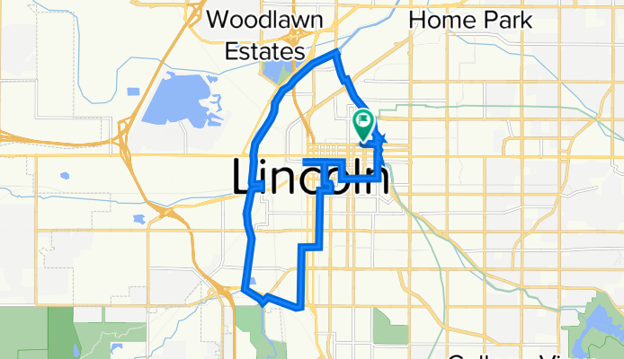
North Antelope Valley Parkway 233, Lincoln to Q Street 1814, Lincoln
A cycling route starting in Lincoln, Nebraska, United States.
Overview
About this route
- 1 h 26 min
- Duration
- 19.3 km
- Distance
- 68 m
- Ascent
- 64 m
- Descent
- 13.5 km/h
- Avg. speed
- 373 m
- Max. altitude

Route quality
Waytypes & surfaces along the route
Waytypes
Cycleway
11.3 km
(58 %)
Pedestrian area
3.7 km
(19 %)
Surfaces
Paved
10.5 km
(54 %)
Unpaved
2.6 km
(13 %)
Concrete
8.3 km
(43 %)
Gravel
1.9 km
(10 %)
Continue with Bikemap
Use, edit, or download this cycling route
You would like to ride North Antelope Valley Parkway 233, Lincoln to Q Street 1814, Lincoln or customize it for your own trip? Here is what you can do with this Bikemap route:
Free features
- Save this route as favorite or in collections
- Copy & plan your own version of this route
- Sync your route with Garmin or Wahoo
Premium features
Free trial for 3 days, or one-time payment. More about Bikemap Premium.
- Navigate this route on iOS & Android
- Export a GPX / KML file of this route
- Create your custom printout (try it for free)
- Download this route for offline navigation
Discover more Premium features.
Get Bikemap PremiumFrom our community
Other popular routes starting in Lincoln
 MoPac
MoPac- Distance
- 94.4 km
- Ascent
- 254 m
- Descent
- 254 m
- Location
- Lincoln, Nebraska, United States
 North Antelope Valley Parkway 233, Lincoln to Q Street 1814, Lincoln
- Distance
- 19.3 km
- Ascent
- 68 m
- Descent
- 64 m
- Location
- Lincoln, Nebraska, United States
 1324 P St, Lincoln to 1531 Hartland Rd, Lincoln
- Distance
- 6.2 km
- Ascent
- 401 m
- Descent
- 389 m
- Location
- Lincoln, Nebraska, United States
 Steady ride in Lincoln
- Distance
- 73.8 km
- Ascent
- 792 m
- Descent
- 773 m
- Location
- Lincoln, Nebraska, United States
 Nebraska Gap 5: Lincoln to Elmwood
- Distance
- 39 km
- Ascent
- 247 m
- Descent
- 224 m
- Location
- Lincoln, Nebraska, United States
 Billy Wolf Trail To Sunken Gardens
- Distance
- 13.3 km
- Ascent
- 40 m
- Descent
- 42 m
- Location
- Lincoln, Nebraska, United States
 Quick bike tour through Lincoln
- Distance
- 4.6 km
- Ascent
- 35 m
- Descent
- 24 m
- Location
- Lincoln, Nebraska, United States
 Eclipse Route
- Distance
- 74.5 km
- Ascent
- 135 m
- Descent
- 132 m
- Location
- Lincoln, Nebraska, United States
Open it in the app