

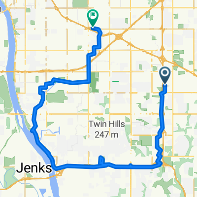
Creek Turnpike W, Broken Arrow to 4827 W New Orleans St, Broken Arrow
A cycling route starting in Broken Arrow, Oklahoma, United States.
Overview
About this route
- 1 h 57 min
- Duration
- 25.4 km
- Distance
- 721 m
- Ascent
- 719 m
- Descent
- 13 km/h
- Avg. speed
- 220 m
- Max. altitude

Continue with Bikemap
Use, edit, or download this cycling route
You would like to ride Creek Turnpike W, Broken Arrow to 4827 W New Orleans St, Broken Arrow or customize it for your own trip? Here is what you can do with this Bikemap route:
Free features
- Save this route as favorite or in collections
- Copy & plan your own version of this route
- Sync your route with Garmin or Wahoo
Premium features
Free trial for 3 days, or one-time payment. More about Bikemap Premium.
- Navigate this route on iOS & Android
- Export a GPX / KML file of this route
- Create your custom printout (try it for free)
- Download this route for offline navigation
Discover more Premium features.
Get Bikemap PremiumFrom our community
Other popular routes starting in Broken Arrow
 601–699 S Redbud Ave, Broken Arrow to 1809 W Galveston St, Broken Arrow
- Distance
- 2.6 km
- Ascent
- 13 m
- Descent
- 10 m
- Location
- Broken Arrow, Oklahoma, United States
 round Tulsa/BA
- Distance
- 107.9 km
- Ascent
- 250 m
- Descent
- 257 m
- Location
- Broken Arrow, Oklahoma, United States
 5635 S 107th E Ave, Tulsa to 5138 E 30th Pl, Tulsa
- Distance
- 38.2 km
- Ascent
- 621 m
- Descent
- 602 m
- Location
- Broken Arrow, Oklahoma, United States
 South Ash Place 1609, Broken Arrow to South Ash Place 1609, Broken Arrow
- Distance
- 16.6 km
- Ascent
- 61 m
- Descent
- 60 m
- Location
- Broken Arrow, Oklahoma, United States
 S 101st E Ave & Mingo Trail, Tulsa to South Mingo Road 8601, Tulsa
- Distance
- 35.5 km
- Ascent
- 206 m
- Descent
- 206 m
- Location
- Broken Arrow, Oklahoma, United States
 South Mingo Road 8601, Tulsa to South Mingo Road 8601, Tulsa
- Distance
- 35.4 km
- Ascent
- 232 m
- Descent
- 239 m
- Location
- Broken Arrow, Oklahoma, United States
 Rode around Broken Arrow, Oklahoma city!!!!
- Distance
- 7.4 km
- Ascent
- 10 m
- Descent
- 9 m
- Location
- Broken Arrow, Oklahoma, United States
 Bazoosa Ride
- Distance
- 89 km
- Ascent
- 395 m
- Descent
- 394 m
- Location
- Broken Arrow, Oklahoma, United States
Open it in the app