

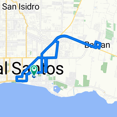
Unnamed Road, General Santos City to 466M+GJ2, General Santos City
A cycling route starting in General Santos, Soccsksargen, Philippines.
Overview
About this route
- 1 h 30 min
- Duration
- 25.3 km
- Distance
- 72 m
- Ascent
- 102 m
- Descent
- 16.8 km/h
- Avg. speed
- 40 m
- Max. altitude

Route photos

Route quality
Waytypes & surfaces along the route
Waytypes
Quiet road
10.4 km
(41 %)
Road
3.5 km
(14 %)
Surfaces
Paved
8.8 km
(35 %)
Asphalt
7.6 km
(30 %)
Concrete
1 km
(4 %)
Continue with Bikemap
Use, edit, or download this cycling route
You would like to ride Unnamed Road, General Santos City to 466M+GJ2, General Santos City or customize it for your own trip? Here is what you can do with this Bikemap route:
Free features
- Save this route as favorite or in collections
- Copy & plan your own version of this route
- Sync your route with Garmin or Wahoo
Premium features
Free trial for 3 days, or one-time payment. More about Bikemap Premium.
- Navigate this route on iOS & Android
- Export a GPX / KML file of this route
- Create your custom printout (try it for free)
- Download this route for offline navigation
Discover more Premium features.
Get Bikemap PremiumFrom our community
Other popular routes starting in General Santos
 Ride (Mar. 08, 2022)
- Distance
- 19.8 km
- Ascent
- 95 m
- Descent
- 95 m
- Location
- General Santos, Soccsksargen, Philippines
 Asai Street, General Santos City to Asai Street, General Santos City
- Distance
- 16.3 km
- Ascent
- 137 m
- Descent
- 205 m
- Location
- General Santos, Soccsksargen, Philippines
 Phil-Am Ave, General Santos City to Unnamed Road, General Santos City
- Distance
- 6.7 km
- Ascent
- 98 m
- Descent
- 11 m
- Location
- General Santos, Soccsksargen, Philippines
 Unnamed Road, General Santos City to 466M+GJ2, General Santos City
- Distance
- 25.3 km
- Ascent
- 72 m
- Descent
- 102 m
- Location
- General Santos, Soccsksargen, Philippines
 34RM+4QC, General Santos City to 34RM+4QC, General Santos City
- Distance
- 24.4 km
- Ascent
- 52 m
- Descent
- 119 m
- Location
- General Santos, Soccsksargen, Philippines
 testdfgdfg
- Distance
- 69.7 km
- Ascent
- 649 m
- Descent
- 664 m
- Location
- General Santos, Soccsksargen, Philippines
 Restful route in
- Distance
- 5.7 km
- Ascent
- 22 m
- Descent
- 28 m
- Location
- General Santos, Soccsksargen, Philippines
 Unnamed Road, General Santos City to Q952+2X2, Digos City
- Distance
- 159 km
- Ascent
- 2,286 m
- Descent
- 2,386 m
- Location
- General Santos, Soccsksargen, Philippines
Open it in the app