

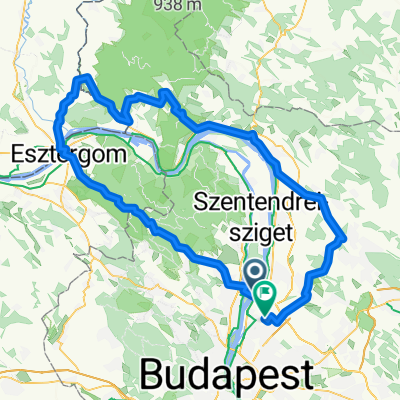
PilisiKanyar
A cycling route starting in Budakalász, Pest County, Hungary.
Overview
About this route
- -:--
- Duration
- 100.7 km
- Distance
- 1,303 m
- Ascent
- 1,303 m
- Descent
- ---
- Avg. speed
- 589 m
- Max. altitude

Route quality
Waytypes & surfaces along the route
Waytypes
Quiet road
34.4 km
(34 %)
Busy road
22.9 km
(23 %)
Surfaces
Paved
78.6 km
(78 %)
Unpaved
6.4 km
(6 %)
Asphalt
77.7 km
(77 %)
Ground
3.6 km
(4 %)
Continue with Bikemap
Use, edit, or download this cycling route
You would like to ride PilisiKanyar or customize it for your own trip? Here is what you can do with this Bikemap route:
Free features
- Save this route as favorite or in collections
- Copy & plan your own version of this route
- Split it into stages to create a multi-day tour
- Sync your route with Garmin or Wahoo
Premium features
Free trial for 3 days, or one-time payment. More about Bikemap Premium.
- Navigate this route on iOS & Android
- Export a GPX / KML file of this route
- Create your custom printout (try it for free)
- Download this route for offline navigation
Discover more Premium features.
Get Bikemap PremiumFrom our community
Other popular routes starting in Budakalász
 Pilis kör (Pomáz-Lajosforrás-Szentlélek-Marót-Kereszt)
- Distance
- 85.9 km
- Ascent
- 1,404 m
- Descent
- 1,404 m
- Location
- Budakalász, Pest County, Hungary
 Pilis Classic
- Distance
- 113.1 km
- Ascent
- 2,400 m
- Descent
- 2,376 m
- Location
- Budakalász, Pest County, Hungary
 Pilis 83
- Distance
- 83.3 km
- Ascent
- 1,428 m
- Descent
- 1,412 m
- Location
- Budakalász, Pest County, Hungary
 Kanonok utca, Budakalász - Széchenyi István utca, Budakalász
- Distance
- 29.2 km
- Ascent
- 180 m
- Descent
- 179 m
- Location
- Budakalász, Pest County, Hungary
 Pilis-Visegrádi Zöld 7
- Distance
- 12.4 km
- Ascent
- 325 m
- Descent
- 304 m
- Location
- Budakalász, Pest County, Hungary
 Szentendrei út 12, Budakalász - Vróci út 40, Pomáz
- Distance
- 48.1 km
- Ascent
- 860 m
- Descent
- 807 m
- Location
- Budakalász, Pest County, Hungary
 Kedves-féle idénynyitó
- Distance
- 84.6 km
- Ascent
- 723 m
- Descent
- 725 m
- Location
- Budakalász, Pest County, Hungary
 Esztergom Letkés Kóspallag
- Distance
- 133.6 km
- Ascent
- 873 m
- Descent
- 872 m
- Location
- Budakalász, Pest County, Hungary
Open it in the app