

Szigeti teker(g)és
A cycling route starting in Szigethalom, Pest County, Hungary.
Overview
About this route
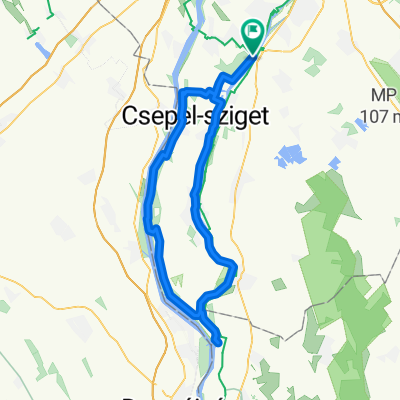
We start from Szigethalom in the direction of Tököl. After leaving the center of Tököl, we turn right in the direction of the Százhalombatta ferry. From the ferry, we take the direction of Szigetújfalu to the left on a dirt road along the banks of the Danube; the scenery is wonderful. At Szigerújfalun, we reached the ferry towards Ercsi; the scenery here is also breathtaking and the other bank is surprisingly 'close'. Upon our return to Szigetújfalu, we follow the European bicycle route 6 towards Ráckeve. About 3 km after Szigetújfalu, there is a road junction where we must keep left, a bicycle sign indicates the correct direction. We arrive in Ráckeve, then cross the HÉV rails and turn right. We pass in front of the castle, then leave the riverside and proceed on the upper road all the way to the center. After leaving the center of Ráckeve, the road to Lórév will be on the right, but we continue our route toward Szigetbecse. The two settlements have merged, so there is only one sign indicating we have arrived in Szigetbecse. Continuing on the main road, the André Kertész Memorial Museum will be on our right, followed by a small artificial pond. After leaving Szigetbecse, we continue our way toward Makád. Describing an 'S' shape, following three almost straight sections, we reach Makád. After about 800 meters, we arrive at the church, which is also the center of the settlement. This quiet little square is also the endpoint of our route. Retracing our steps along the described route, we reach Ráckeve. If time allows, we can divert from Makád toward Lórév. Upon entering Lórév, we turn left toward the Adony ferry. From here, we return to Lórév and continue toward Ráckeve. Entering Ráckeve, we pass through the center of the settlement, then cross the Árpád Bridge. After that, we turn left and descend to the Kis Duna's shore. We pass through a built-up recreation area until we reach the boundary of Áporka, where a field blocks our way. To get to Majosháza, we turn left and cross to Majosháza on a dirt road along the Danube. The dirt section is about 5 km long. After reaching Majosháza, we continue along the beautiful resort area until the Danube Bridge, where by turning left we return to Szigethalom.
- -:--
- Duration
- 79.5 km
- Distance
- 43 m
- Ascent
- 43 m
- Descent
- ---
- Avg. speed
- ---
- Max. altitude

Route quality
Waytypes & surfaces along the route
Waytypes
Road
27 km
(34 %)
Quiet road
21.5 km
(27 %)
Surfaces
Paved
55.6 km
(70 %)
Unpaved
4 km
(5 %)
Asphalt
54.8 km
(69 %)
Ground
2.4 km
(3 %)
Route highlights
Points of interest along the route
és\"")
Photo after 7.1 km
Tököl-i kompátkelő
és\"")
Photo after 7.3 km
Dunapart
és\"")
Photo after 20.3 km
Kompátkelő Szigetújfalu
és\"")
Photo after 31.2 km
Ráckeve központ
és\"")
Photo after 56.8 km
Ráckeve - Árpád híd
Continue with Bikemap
Use, edit, or download this cycling route
You would like to ride Szigeti teker(g)és or customize it for your own trip? Here is what you can do with this Bikemap route:
Free features
- Save this route as favorite or in collections
- Copy & plan your own version of this route
- Sync your route with Garmin or Wahoo
Premium features
Free trial for 3 days, or one-time payment. More about Bikemap Premium.
- Navigate this route on iOS & Android
- Export a GPX / KML file of this route
- Create your custom printout (try it for free)
- Download this route for offline navigation
Discover more Premium features.
Get Bikemap PremiumFrom our community
Other popular routes starting in Szigethalom
 csepel nagykőr
- Distance
- 82.9 km
- Ascent
- 48 m
- Descent
- 45 m
- Location
- Szigethalom, Pest County, Hungary
 Roundtour - 60km
- Distance
- 59.4 km
- Ascent
- 114 m
- Descent
- 111 m
- Location
- Szigethalom, Pest County, Hungary
 Szigeti teker(g)és
- Distance
- 79.5 km
- Ascent
- 43 m
- Descent
- 43 m
- Location
- Szigethalom, Pest County, Hungary
 Szigethalom - Árpád-híd bicikliúton
- Distance
- 36.1 km
- Ascent
- 94 m
- Descent
- 85 m
- Location
- Szigethalom, Pest County, Hungary
 Nadapi pokol
- Distance
- 152.6 km
- Ascent
- 573 m
- Descent
- 570 m
- Location
- Szigethalom, Pest County, Hungary
 Dr. Nagy Sándor: KERÉKPÁRON Budapest körül IV.
- Distance
- 11.6 km
- Ascent
- 12 m
- Descent
- 12 m
- Location
- Szigethalom, Pest County, Hungary
 Rózsa utca, Szigethalom to Százszorszép utca, Szigethalom
- Distance
- 42.9 km
- Ascent
- 174 m
- Descent
- 174 m
- Location
- Szigethalom, Pest County, Hungary
 Halom-Tas
- Distance
- 40.1 km
- Ascent
- 6 m
- Descent
- 9 m
- Location
- Szigethalom, Pest County, Hungary
Open it in the app