

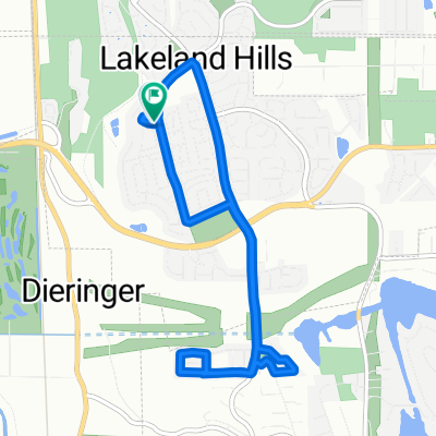
14256–14266 Stewart Rd SE, Sumner to 8430 27th Street Ct E, Edgewood
A cycling route starting in Pacific, Washington, United States.
Overview
About this route
- 1 h 24 min
- Duration
- 24.7 km
- Distance
- 297 m
- Ascent
- 226 m
- Descent
- 17.6 km/h
- Avg. speed
- 140 m
- Max. altitude

Route quality
Waytypes & surfaces along the route
Waytypes
Cycleway
10.8 km
(44 %)
Road
8.1 km
(33 %)
Surfaces
Paved
8.4 km
(34 %)
Paved (undefined)
4.7 km
(19 %)
Asphalt
3.7 km
(15 %)
Undefined
16.3 km
(66 %)
Continue with Bikemap
Use, edit, or download this cycling route
You would like to ride 14256–14266 Stewart Rd SE, Sumner to 8430 27th Street Ct E, Edgewood or customize it for your own trip? Here is what you can do with this Bikemap route:
Free features
- Save this route as favorite or in collections
- Copy & plan your own version of this route
- Sync your route with Garmin or Wahoo
Premium features
Free trial for 3 days, or one-time payment. More about Bikemap Premium.
- Navigate this route on iOS & Android
- Export a GPX / KML file of this route
- Create your custom printout (try it for free)
- Download this route for offline navigation
Discover more Premium features.
Get Bikemap PremiumFrom our community
Other popular routes starting in Pacific
 2323 185th Ave E, Lake Tapps to 2323 185th Ave E, Lake Tapps
- Distance
- 4,151.7 km
- Ascent
- 45 m
- Descent
- 47 m
- Location
- Pacific, Washington, United States
 Potential Marathon Route
- Distance
- 43.1 km
- Ascent
- 31 m
- Descent
- 49 m
- Location
- Pacific, Washington, United States
 1502 Lake Tapps Pkwy SE, Auburn to 14218 Stewart Rd SE, Sumner
- Distance
- 2.9 km
- Ascent
- 22 m
- Descent
- 220 m
- Location
- Pacific, Washington, United States
 230 Frontage Rd S, Pacific to 1196 Industry Dr N, Algona
- Distance
- 21.4 km
- Ascent
- 120 m
- Descent
- 121 m
- Location
- Pacific, Washington, United States
 3rd Avenue Southwest 400, Pacific to Interurban Avenue South 13980, Tukwila
- Distance
- 34 km
- Ascent
- 29 m
- Descent
- 44 m
- Location
- Pacific, Washington, United States
 High-speed route in Auburn
- Distance
- 8.7 km
- Ascent
- 91 m
- Descent
- 84 m
- Location
- Pacific, Washington, United States
 6521 Quincy Ave SE, Auburn to 6521 Quincy Ave SE, Auburn
- Distance
- 14.8 km
- Ascent
- 176 m
- Descent
- 171 m
- Location
- Pacific, Washington, United States
 819 61st St SE, Auburn to 821 61st St SE, Auburn
- Distance
- 7.7 km
- Ascent
- 55 m
- Descent
- 60 m
- Location
- Pacific, Washington, United States
Open it in the app