
Hase-Ems-Weg - 1 Tag
A cycling route starting in Rheine, North Rhine-Westphalia, Germany.
Overview
About this route
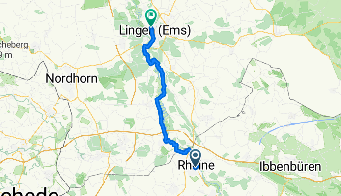
Der Hase-Ems-Weg im Herzen des Emslandes startet bzw. endet in Rheine, je nachdem in welche Richtung man startet. Am ersten Tag sind wir in Rheine gestartet und bis nach Lingen gefahren. Übernachten kann man hier gut in der Jugendherberge, die jedoch etwas außerhalb von Lingen liegt. Von Rheine bis nach Lingen fährt man fast ausschließlich auf Nebenwegen oder auf Waldwegen. Unberührte Natur satt. Uns hat der erste Tag außerordentlich gut gefallen. Besonders das Angebot an Gastronomiebetrieben und Schutzhütten entlang der Strecke ist ausgezeichnet.
- -:--
- Duration
- 41.7 km
- Distance
- 63 m
- Ascent
- 75 m
- Descent
- ---
- Avg. speed
- 45 m
- Max. altitude

Route quality
Waytypes & surfaces along the route
Waytypes
Quiet road
14.4 km
(34 %)
Track
11.3 km
(27 %)
Surfaces
Paved
26.5 km
(64 %)
Unpaved
12 km
(29 %)
Asphalt
23.6 km
(57 %)
Ground
5.3 km
(13 %)
Continue with Bikemap
Use, edit, or download this cycling route
You would like to ride Hase-Ems-Weg - 1 Tag or customize it for your own trip? Here is what you can do with this Bikemap route:
Free features
- Save this route as favorite or in collections
- Copy & plan your own version of this route
- Sync your route with Garmin or Wahoo
Premium features
Free trial for 3 days, or one-time payment. More about Bikemap Premium.
- Navigate this route on iOS & Android
- Export a GPX / KML file of this route
- Create your custom printout (try it for free)
- Download this route for offline navigation
Discover more Premium features.
Get Bikemap PremiumFrom our community
Other popular routes starting in Rheine
 Rheine-Hörstel-Nasses Dreieck CLONED FROM ROUTE 71643
- Distance
- 32.4 km
- Ascent
- 61 m
- Descent
- 65 m
- Location
- Rheine, North Rhine-Westphalia, Germany
 Radbahn Münsterland
- Distance
- 36.4 km
- Ascent
- 101 m
- Descent
- 53 m
- Location
- Rheine, North Rhine-Westphalia, Germany
 Rheine-Ewige Liebe
- Distance
- 29.9 km
- Ascent
- 72 m
- Descent
- 69 m
- Location
- Rheine, North Rhine-Westphalia, Germany
 Elte-Emsdetten-Neuenkirchen-Tour
- Distance
- 44.7 km
- Ascent
- 84 m
- Descent
- 83 m
- Location
- Rheine, North Rhine-Westphalia, Germany
 Hase-Ems-Weg - 1 Tag
- Distance
- 41.7 km
- Ascent
- 63 m
- Descent
- 75 m
- Location
- Rheine, North Rhine-Westphalia, Germany
 Rheine - Haddorf - Neuenkirchen - Rheine
- Distance
- 22 km
- Ascent
- 45 m
- Descent
- 47 m
- Location
- Rheine, North Rhine-Westphalia, Germany
 Rundstrecke Rheine Mesum Elte
- Distance
- 32.5 km
- Ascent
- 81 m
- Descent
- 81 m
- Location
- Rheine, North Rhine-Westphalia, Germany
 Hermannsweg I
- Distance
- 46.5 km
- Ascent
- 172 m
- Descent
- 171 m
- Location
- Rheine, North Rhine-Westphalia, Germany
Open it in the app