

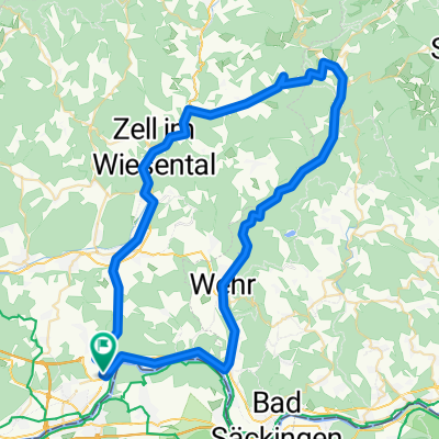
Tour de Dinkelberg
A cycling route starting in Rheinfelden, Baden-Wurttemberg, Germany.
Overview
About this route
- -:--
- Duration
- 36.2 km
- Distance
- 443 m
- Ascent
- 443 m
- Descent
- ---
- Avg. speed
- ---
- Max. altitude
Route quality
Waytypes & surfaces along the route
Waytypes
Quiet road
14.5 km
(40 %)
Road
8 km
(22 %)
Surfaces
Paved
31.1 km
(86 %)
Unpaved
1.4 km
(4 %)
Asphalt
30.4 km
(84 %)
Gravel
1.4 km
(4 %)
Continue with Bikemap
Use, edit, or download this cycling route
You would like to ride Tour de Dinkelberg or customize it for your own trip? Here is what you can do with this Bikemap route:
Free features
- Save this route as favorite or in collections
- Copy & plan your own version of this route
- Sync your route with Garmin or Wahoo
Premium features
Free trial for 3 days, or one-time payment. More about Bikemap Premium.
- Navigate this route on iOS & Android
- Export a GPX / KML file of this route
- Create your custom printout (try it for free)
- Download this route for offline navigation
Discover more Premium features.
Get Bikemap PremiumFrom our community
Other popular routes starting in Rheinfelden
 Tour de Dinkelberg
- Distance
- 36.2 km
- Ascent
- 443 m
- Descent
- 443 m
- Location
- Rheinfelden, Baden-Wurttemberg, Germany
 Rheinfelden - Gelterkinden - Rheinfelden
- Distance
- 51.8 km
- Ascent
- 575 m
- Descent
- 575 m
- Location
- Rheinfelden, Baden-Wurttemberg, Germany
 1a2
1a2- Distance
- 36.4 km
- Ascent
- 267 m
- Descent
- 266 m
- Location
- Rheinfelden, Baden-Wurttemberg, Germany
 Todtmoos und Zurück
- Distance
- 69.4 km
- Ascent
- 882 m
- Descent
- 882 m
- Location
- Rheinfelden, Baden-Wurttemberg, Germany
 Scheideck Wollbach
- Distance
- 63.1 km
- Ascent
- 515 m
- Descent
- 515 m
- Location
- Rheinfelden, Baden-Wurttemberg, Germany
 SS-RW 3.E Obereichsel (Rheinfelden) - Bad Krozingen
- Distance
- 65.3 km
- Ascent
- 472 m
- Descent
- 675 m
- Location
- Rheinfelden, Baden-Wurttemberg, Germany
 Degerfelden-Adelhausen
- Distance
- 16.1 km
- Ascent
- 235 m
- Descent
- 228 m
- Location
- Rheinfelden, Baden-Wurttemberg, Germany
 St. Chrischona - Adelhausen
- Distance
- 34.4 km
- Ascent
- 470 m
- Descent
- 468 m
- Location
- Rheinfelden, Baden-Wurttemberg, Germany
Open it in the app