

Majdalenky, Ujezd, Vyhon, Home
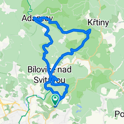
A cycling route starting in Bílovice nad Svitavou, South Moravian, Czechia.
Overview
About this route
- 2 h 56 min
- Duration
- 57.7 km
- Distance
- 464 m
- Ascent
- 466 m
- Descent
- 19.7 km/h
- Avg. speed
- 353 m
- Max. altitude
Route quality
Waytypes & surfaces along the route
Waytypes
Road
16.2 km
(28 %)
Quiet road
11.5 km
(20 %)
Surfaces
Paved
52.5 km
(91 %)
Unpaved
1.7 km
(3 %)
Asphalt
52.5 km
(91 %)
Ground
1.2 km
(2 %)
Continue with Bikemap
Use, edit, or download this cycling route
You would like to ride Majdalenky, Ujezd, Vyhon, Home or customize it for your own trip? Here is what you can do with this Bikemap route:
Free features
- Save this route as favorite or in collections
- Copy & plan your own version of this route
- Sync your route with Garmin or Wahoo
Premium features
Free trial for 3 days, or one-time payment. More about Bikemap Premium.
- Navigate this route on iOS & Android
- Export a GPX / KML file of this route
- Create your custom printout (try it for free)
- Download this route for offline navigation
Discover more Premium features.
Get Bikemap PremiumFrom our community
Other popular routes starting in Bílovice nad Svitavou
 Kondiční vyjížďka
- Distance
- 24.2 km
- Ascent
- 305 m
- Descent
- 305 m
- Location
- Bílovice nad Svitavou, South Moravian, Czechia
 kolečko po Brně
- Distance
- 34.9 km
- Ascent
- 373 m
- Descent
- 370 m
- Location
- Bílovice nad Svitavou, South Moravian, Czechia
 Kanice Kalečník Ùdolí Říčky
- Distance
- 31.6 km
- Ascent
- 414 m
- Descent
- 413 m
- Location
- Bílovice nad Svitavou, South Moravian, Czechia
 02.09.18
- Distance
- 48.4 km
- Ascent
- 889 m
- Descent
- 891 m
- Location
- Bílovice nad Svitavou, South Moravian, Czechia
 Vyhlídka
- Distance
- 27.4 km
- Ascent
- 339 m
- Descent
- 338 m
- Location
- Bílovice nad Svitavou, South Moravian, Czechia
 bike 29.4.2012 - canyon
- Distance
- 37.8 km
- Ascent
- 722 m
- Descent
- 722 m
- Location
- Bílovice nad Svitavou, South Moravian, Czechia
 Lesna-bilovice-Adamov-Krtiny-Blansko-Olesna
- Distance
- 62.8 km
- Ascent
- 1,521 m
- Descent
- 1,409 m
- Location
- Bílovice nad Svitavou, South Moravian, Czechia
 Lisen - Kalecnik - Lisen
- Distance
- 33.9 km
- Ascent
- 429 m
- Descent
- 445 m
- Location
- Bílovice nad Svitavou, South Moravian, Czechia
Open it in the app