

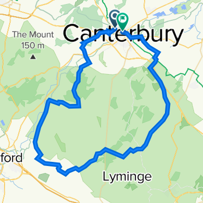
Bridge-Sandwich-Loop
A cycling route starting in Canterbury, England, United Kingdom.
Overview
About this route
- 1 h 53 min
- Duration
- 46.8 km
- Distance
- 358 m
- Ascent
- 319 m
- Descent
- 24.9 km/h
- Avg. speed
- 65 m
- Max. altitude
Route quality
Waytypes & surfaces along the route
Waytypes
Road
28.1 km
(60 %)
Quiet road
18.2 km
(39 %)
Undefined
0.5 km
(1 %)
Surfaces
Paved
25.2 km
(54 %)
Asphalt
25.2 km
(54 %)
Undefined
21.5 km
(46 %)
Continue with Bikemap
Use, edit, or download this cycling route
You would like to ride Bridge-Sandwich-Loop or customize it for your own trip? Here is what you can do with this Bikemap route:
Free features
- Save this route as favorite or in collections
- Copy & plan your own version of this route
- Sync your route with Garmin or Wahoo
Premium features
Free trial for 3 days, or one-time payment. More about Bikemap Premium.
- Navigate this route on iOS & Android
- Export a GPX / KML file of this route
- Create your custom printout (try it for free)
- Download this route for offline navigation
Discover more Premium features.
Get Bikemap PremiumFrom our community
Other popular routes starting in Canterbury
 Long Afternoon Ride In Whitstable
- Distance
- 10.3 km
- Ascent
- 118 m
- Descent
- 104 m
- Location
- Canterbury, England, United Kingdom
 FH Wye Stelling Minnis
- Distance
- 47.8 km
- Ascent
- 290 m
- Descent
- 293 m
- Location
- Canterbury, England, United Kingdom
 pilgrims
- Distance
- 65.5 km
- Ascent
- 438 m
- Descent
- 435 m
- Location
- Canterbury, England, United Kingdom
 The Classic - 50 miles - The Classic - 50 miles
- Distance
- 60.6 km
- Ascent
- 651 m
- Descent
- 666 m
- Location
- Canterbury, England, United Kingdom
 Sunday ride
- Distance
- 98 km
- Ascent
- 547 m
- Descent
- 547 m
- Location
- Canterbury, England, United Kingdom
 Coastal route
- Distance
- 92.7 km
- Ascent
- 288 m
- Descent
- 298 m
- Location
- Canterbury, England, United Kingdom
 Day 2 Kent
- Distance
- 63.3 km
- Ascent
- 380 m
- Descent
- 380 m
- Location
- Canterbury, England, United Kingdom
 South Canterbury round 2
- Distance
- 34.2 km
- Ascent
- 267 m
- Descent
- 267 m
- Location
- Canterbury, England, United Kingdom
Open it in the app