

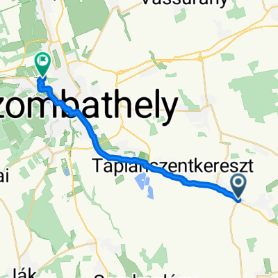
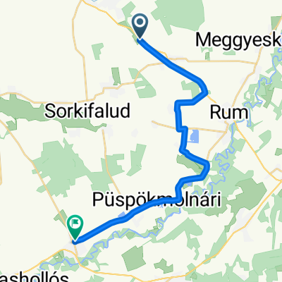
Péteri köz, Táplánszentkereszt - Rákóczi Ferenc utca 7, Rum
A cycling route starting in Táplánszentkereszt, Vas County, Hungary.
Overview
About this route
- 56 min
- Duration
- 16.1 km
- Distance
- 6 m
- Ascent
- 31 m
- Descent
- 17.3 km/h
- Avg. speed
- 246 m
- Max. altitude

Route quality
Waytypes & surfaces along the route
Waytypes
Cycleway
12.2 km
(76 %)
Quiet road
3.1 km
(19 %)
Undefined
0.8 km
(5 %)
Surfaces
Paved
14.5 km
(90 %)
Asphalt
14.5 km
(90 %)
Undefined
1.6 km
(10 %)
Continue with Bikemap
Use, edit, or download this cycling route
You would like to ride Péteri köz, Táplánszentkereszt - Rákóczi Ferenc utca 7, Rum or customize it for your own trip? Here is what you can do with this Bikemap route:
Free features
- Save this route as favorite or in collections
- Copy & plan your own version of this route
- Sync your route with Garmin or Wahoo
Premium features
Free trial for 3 days, or one-time payment. More about Bikemap Premium.
- Navigate this route on iOS & Android
- Export a GPX / KML file of this route
- Create your custom printout (try it for free)
- Download this route for offline navigation
Discover more Premium features.
Get Bikemap PremiumFrom our community
Other popular routes starting in Táplánszentkereszt
 Petőfi Sándor utca, Vasszécseny - Kassák Lajos utca, Szombathely
- Distance
- 16.8 km
- Ascent
- 168 m
- Descent
- 127 m
- Location
- Táplánszentkereszt, Vas County, Hungary
 Rákóczi Ferenc utca 20, Vasszécseny to Rákóczi Ferenc utca 20, Vasszécseny
- Distance
- 21 km
- Ascent
- 83 m
- Descent
- 88 m
- Location
- Táplánszentkereszt, Vas County, Hungary
 Szentkirály-Sé-Bucsu-Szentkirály
- Distance
- 48.6 km
- Ascent
- 146 m
- Descent
- 192 m
- Location
- Táplánszentkereszt, Vas County, Hungary
 E-bike túra Szombathelyről...
- Distance
- 36.4 km
- Ascent
- 30 m
- Descent
- 30 m
- Location
- Táplánszentkereszt, Vas County, Hungary
 Szombathely-Rauchwart
- Distance
- 42.3 km
- Ascent
- 226 m
- Descent
- 196 m
- Location
- Táplánszentkereszt, Vas County, Hungary
 VELOREGIO_12.
- Distance
- 28.1 km
- Ascent
- 33 m
- Descent
- 33 m
- Location
- Táplánszentkereszt, Vas County, Hungary
 PANTÉR - VHR
- Distance
- 18.4 km
- Ascent
- 13 m
- Descent
- 16 m
- Location
- Táplánszentkereszt, Vas County, Hungary
 Vasarnapi karika
- Distance
- 81.4 km
- Ascent
- 269 m
- Descent
- 269 m
- Location
- Táplánszentkereszt, Vas County, Hungary
Open it in the app