
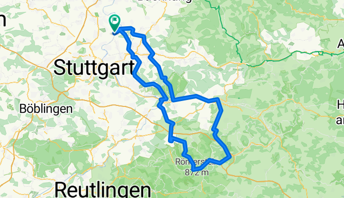
Remseck - Remstal - Filstal - Schw. Alb
A cycling route starting in Stuttgart Mühlhausen, Baden-Wurttemberg, Germany.
Overview
About this route
Intensive training round for 'advanced' cyclists. Three 'waves' to conquer:Schurwald - Swabian Jura - Schurwald
-- with a short, steep climb just behind Bad Boll towards Gruibingen. All other climbs are more relaxed at a 6 - 8% gradient.
The actual challenge of this round lies in the absolute length. However, it offers plenty of opportunities for shortcuts. The charm of this round is in the changing scenery:
From the lovely Rems and Filstal valleys to the rough high plateau of the Jura. In spring, climatically 'varied'.
- -:--
- Duration
- 142.2 km
- Distance
- 1,893 m
- Ascent
- 1,843 m
- Descent
- ---
- Avg. speed
- 804 m
- Max. altitude
Route quality
Waytypes & surfaces along the route
Waytypes
Road
61.1 km
(43 %)
Quiet road
12.8 km
(9 %)
Surfaces
Paved
123.7 km
(87 %)
Asphalt
120.8 km
(85 %)
Paved (undefined)
2.8 km
(2 %)
Undefined
18.5 km
(13 %)
Continue with Bikemap
Use, edit, or download this cycling route
You would like to ride Remseck - Remstal - Filstal - Schw. Alb or customize it for your own trip? Here is what you can do with this Bikemap route:
Free features
- Save this route as favorite or in collections
- Copy & plan your own version of this route
- Split it into stages to create a multi-day tour
- Sync your route with Garmin or Wahoo
Premium features
Free trial for 3 days, or one-time payment. More about Bikemap Premium.
- Navigate this route on iOS & Android
- Export a GPX / KML file of this route
- Create your custom printout (try it for free)
- Download this route for offline navigation
Discover more Premium features.
Get Bikemap PremiumFrom our community
Other popular routes starting in Stuttgart Mühlhausen
 Fellbach-Baden-Baden 2
- Distance
- 119.3 km
- Ascent
- 1,054 m
- Descent
- 1,186 m
- Location
- Stuttgart Mühlhausen, Baden-Wurttemberg, Germany
 18.09.25: Von Fellbach bis Châlons-en-Champagne (Bahn, BB Hotel)
- Distance
- 504.8 km
- Ascent
- 4,621 m
- Descent
- 4,819 m
- Location
- Stuttgart Mühlhausen, Baden-Wurttemberg, Germany
 RTF Rund um Stuttgart
- Distance
- 162.4 km
- Ascent
- 875 m
- Descent
- 871 m
- Location
- Stuttgart Mühlhausen, Baden-Wurttemberg, Germany
 Running Route along the Neckar and Max-Eyth-See
- Distance
- 12.7 km
- Ascent
- 57 m
- Descent
- 69 m
- Location
- Stuttgart Mühlhausen, Baden-Wurttemberg, Germany
 Remseck - Remstal - Filstal - Schw. Alb
- Distance
- 142.2 km
- Ascent
- 1,893 m
- Descent
- 1,843 m
- Location
- Stuttgart Mühlhausen, Baden-Wurttemberg, Germany
 Robinson To Patch Barracks
- Distance
- 18 km
- Ascent
- 340 m
- Descent
- 198 m
- Location
- Stuttgart Mühlhausen, Baden-Wurttemberg, Germany
 Robinson To Patch Barracks
- Distance
- 18 km
- Ascent
- 339 m
- Descent
- 194 m
- Location
- Stuttgart Mühlhausen, Baden-Wurttemberg, Germany
 Löwensteiner Sonntagsrunde
- Distance
- 96.9 km
- Ascent
- 1,331 m
- Descent
- 1,296 m
- Location
- Stuttgart Mühlhausen, Baden-Wurttemberg, Germany
Open it in the app