

Wolności 35, Łuków do Wolności 36, Łuków
A cycling route starting in Czernica, Silesian Voivodeship, Poland.
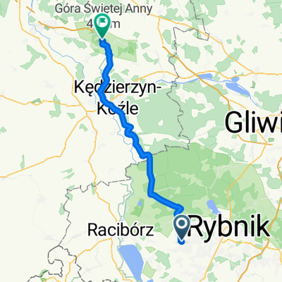
Overview
About this route
- 1 h 56 min
- Duration
- 19 km
- Distance
- 291 m
- Ascent
- 302 m
- Descent
- 9.8 km/h
- Avg. speed
- 269 m
- Max. altitude
Route quality
Waytypes & surfaces along the route
Waytypes
Quiet road
5.9 km
(31 %)
Road
5.1 km
(27 %)
Surfaces
Paved
9.5 km
(50 %)
Unpaved
6.5 km
(34 %)
Asphalt
8.9 km
(47 %)
Ground
2.5 km
(13 %)
Continue with Bikemap
Use, edit, or download this cycling route
You would like to ride Wolności 35, Łuków do Wolności 36, Łuków or customize it for your own trip? Here is what you can do with this Bikemap route:
Free features
- Save this route as favorite or in collections
- Copy & plan your own version of this route
- Sync your route with Garmin or Wahoo
Premium features
Free trial for 3 days, or one-time payment. More about Bikemap Premium.
- Navigate this route on iOS & Android
- Export a GPX / KML file of this route
- Create your custom printout (try it for free)
- Download this route for offline navigation
Discover more Premium features.
Get Bikemap PremiumFrom our community
Other popular routes starting in Czernica
 Powstańców, Czernica do Chwałęcice, Rybnik
- Distance
- 12.6 km
- Ascent
- 83 m
- Descent
- 132 m
- Location
- Czernica, Silesian Voivodeship, Poland
 Graniczna 10, Czernica do Graniczna 10, Czernica
- Distance
- 20 km
- Ascent
- 223 m
- Descent
- 224 m
- Location
- Czernica, Silesian Voivodeship, Poland
 Osiedle Na Wzgórzu 82, Rydułtowy do Osiedle Na Wzgórzu 82, Rydułtowy
- Distance
- 46.9 km
- Ascent
- 1,871 m
- Descent
- 1,873 m
- Location
- Czernica, Silesian Voivodeship, Poland
 Jezioro Rybnickie
- Distance
- 49.4 km
- Ascent
- 312 m
- Descent
- 300 m
- Location
- Czernica, Silesian Voivodeship, Poland
 Graniczna 10, Czernica do Graniczna 10, Czernica
- Distance
- 17.4 km
- Ascent
- 185 m
- Descent
- 185 m
- Location
- Czernica, Silesian Voivodeship, Poland
 Piecowska 1, Rydułtowy do Raciborska 417, Rydułtowy
- Distance
- 25 km
- Ascent
- 233 m
- Descent
- 230 m
- Location
- Czernica, Silesian Voivodeship, Poland
 Czernica - Annaberg
- Distance
- 57.5 km
- Ascent
- 271 m
- Descent
- 191 m
- Location
- Czernica, Silesian Voivodeship, Poland
 antosovice
- Distance
- 26.5 km
- Ascent
- 200 m
- Descent
- 294 m
- Location
- Czernica, Silesian Voivodeship, Poland
Open it in the app