

👑 Korona Gór Powiatu Żarskiego 👑
👑 Korona Gór Powiatu Żarskiego 👑 8️⃣3️⃣ 👑 TRASA 5 👑
A cycling route starting in Żary, Lubusz Voivodship, Poland.
Overview
About this route
- -:--
- Duration
- 83.1 km
- Distance
- 359 m
- Ascent
- 376 m
- Descent
- ---
- Avg. speed
- 196 m
- Max. altitude

Part of
👑 Korona Gór Powiatu Żarskiego 👑
4 stages
Route photos


Route quality
Waytypes & surfaces along the route
Waytypes
Road
38.2 km
(46 %)
Track
18.3 km
(22 %)
Surfaces
Paved
28.3 km
(34 %)
Unpaved
9.1 km
(11 %)
Asphalt
26.6 km
(32 %)
Gravel
5.8 km
(7 %)
Route highlights
Points of interest along the route

Photo after 21.2 km

Photo after 21.7 km

Photo after 37.5 km
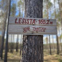
BIEŹDZIAD (111 m n.p.m.) GMINA BRODY

Photo after 48.3 km
SOSNA OŚMIORNICA

Photo after 51.8 km
JEZIORO GŁĘBOKIE
Continue with Bikemap
Use, edit, or download this cycling route
You would like to ride 👑 Korona Gór Powiatu Żarskiego 👑 8️⃣3️⃣ 👑 TRASA 5 👑 or customize it for your own trip? Here is what you can do with this Bikemap route:
Free features
- Save this route as favorite or in collections
- Copy & plan your own version of this route
- Split it into stages to create a multi-day tour
- Sync your route with Garmin or Wahoo
Premium features
Free trial for 3 days, or one-time payment. More about Bikemap Premium.
- Navigate this route on iOS & Android
- Export a GPX / KML file of this route
- Create your custom printout (try it for free)
- Download this route for offline navigation
Discover more Premium features.
Get Bikemap PremiumFrom our community
Other popular routes starting in Żary
 Park Mużakowski 9️⃣0️⃣🚴🏻🌲🌳
- Distance
- 90.1 km
- Ascent
- 510 m
- Descent
- 511 m
- Location
- Żary, Lubusz Voivodship, Poland
 Rezerwat UROCZYSKO WĘGLIŃSKIE
- Distance
- 96.2 km
- Ascent
- 306 m
- Descent
- 306 m
- Location
- Żary, Lubusz Voivodship, Poland
 👑 Korona Gór Powiatu Żarskiego 👑 7️⃣3️⃣ 👑 TRASA 6 👑
- Distance
- 77.1 km
- Ascent
- 235 m
- Descent
- 234 m
- Location
- Żary, Lubusz Voivodship, Poland
 👑 Korona Gór Powiatu Żarskiego 👑 8️⃣3️⃣ 👑 TRASA 5 👑
- Distance
- 83.1 km
- Ascent
- 359 m
- Descent
- 376 m
- Location
- Żary, Lubusz Voivodship, Poland
 👑 Korona Gór Powiatu Żarskiego 👑 6️⃣0️⃣ 👑 TRASA 1 👑
- Distance
- 60.8 km
- Ascent
- 536 m
- Descent
- 745 m
- Location
- Żary, Lubusz Voivodship, Poland
 Zielony Las 5️⃣2️⃣🚴🏻🌲🌳
- Distance
- 51.6 km
- Ascent
- 343 m
- Descent
- 339 m
- Location
- Żary, Lubusz Voivodship, Poland
 Forst (via Lubsko) 🚴🏻♂️💨🇩🇪
- Distance
- 111.3 km
- Ascent
- 189 m
- Descent
- 186 m
- Location
- Żary, Lubusz Voivodship, Poland
 Męczenników Oświęcimskich 15, Żary to Katowicka 30, Żary
- Distance
- 19.6 km
- Ascent
- 166 m
- Descent
- 172 m
- Location
- Żary, Lubusz Voivodship, Poland
Open it in the app