

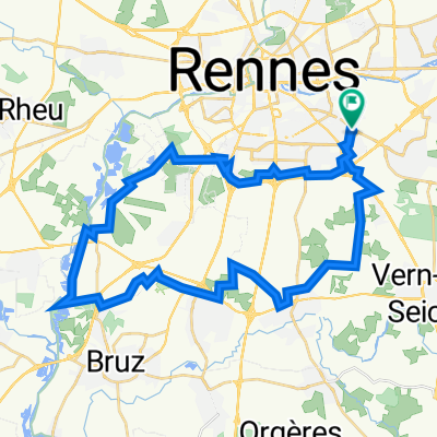
Circuit VTT en Pays de Rennes n°17 : Vallée de la Seiche
A cycling route starting in Chantepie, Brittany Region, France.
Overview
About this route
This route, located at the gates of Brittany, starts from the La Poterie metro station before joining the Seiche valley between Noyal-Châtillon-sur-Seiche and Vern-sur-Seiche, which you will follow to then climb towards the Bois de Soeuvres. Very popular, this wood is a true green lung that will lead you to Chantepie. Official FFCT marking - No. 17 + Blue square Guide 'VTT en Pays de Rennes' available at the Tourist Office: 6 euros
- -:--
- Duration
- 32.3 km
- Distance
- 0 m
- Ascent
- 0 m
- Descent
- ---
- Avg. speed
- 0 m
- Max. altitude
Continue with Bikemap
Use, edit, or download this cycling route
You would like to ride Circuit VTT en Pays de Rennes n°17 : Vallée de la Seiche or customize it for your own trip? Here is what you can do with this Bikemap route:
Free features
- Save this route as favorite or in collections
- Copy & plan your own version of this route
- Sync your route with Garmin or Wahoo
Premium features
Free trial for 3 days, or one-time payment. More about Bikemap Premium.
- Navigate this route on iOS & Android
- Export a GPX / KML file of this route
- Create your custom printout (try it for free)
- Download this route for offline navigation
Discover more Premium features.
Get Bikemap PremiumFrom our community
Other popular routes starting in Chantepie
 Enregistré via Apple Watch à 17 déc. à 18:23
- Distance
- 29.4 km
- Ascent
- 161 m
- Descent
- 163 m
- Location
- Chantepie, Brittany Region, France
 Tour de France 2011 - Etappe 5 - Rennes - La Roche-sour-Yon
- Distance
- 191.6 km
- Ascent
- 400 m
- Descent
- 378 m
- Location
- Chantepie, Brittany Region, France
 test
test- Distance
- 70.1 km
- Ascent
- 283 m
- Descent
- 283 m
- Location
- Chantepie, Brittany Region, France
 Circuit VTT en Pays de Rennes n°17 : Vallée de la Seiche
- Distance
- 32.3 km
- Ascent
- 0 m
- Descent
- 0 m
- Location
- Chantepie, Brittany Region, France
 Vélo - Entrainement tri 20+6
- Distance
- 22.5 km
- Ascent
- 84 m
- Descent
- 82 m
- Location
- Chantepie, Brittany Region, France
 St Grégoire
- Distance
- 12.7 km
- Ascent
- 88 m
- Descent
- 140 m
- Location
- Chantepie, Brittany Region, France
 2305_Bretagne_Jour1
- Distance
- 111.2 km
- Ascent
- 491 m
- Descent
- 541 m
- Location
- Chantepie, Brittany Region, France
 45 Rue Louis Pétri, Rennes to 50 Rue Louis Pétri, Rennes
- Distance
- 39.3 km
- Ascent
- 161 m
- Descent
- 160 m
- Location
- Chantepie, Brittany Region, France
Open it in the app