
660 Southern Belle Blvd, Beavercreek to 656 Southern Belle Blvd, Beavercreek
A cycling route starting in Beaver Creek, Ohio, United States of America.
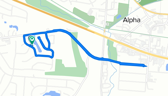
Overview
About this route
- 22 min
- Duration
- 6.2 km
- Distance
- 26 m
- Ascent
- 24 m
- Descent
- 17.3 km/h
- Avg. speed
- 260 m
- Max. altitude
Continue with Bikemap
Use, edit, or download this cycling route
You would like to ride 660 Southern Belle Blvd, Beavercreek to 656 Southern Belle Blvd, Beavercreek or customize it for your own trip? Here is what you can do with this Bikemap route:
Free features
- Save this route as favorite or in collections
- Copy & plan your own version of this route
- Sync your route with Garmin or Wahoo
Premium features
Free trial for 3 days, or one-time payment. More about Bikemap Premium.
- Navigate this route on iOS & Android
- Export a GPX / KML file of this route
- Create your custom printout (try it for free)
- Download this route for offline navigation
Discover more Premium features.
Get Bikemap PremiumFrom our community
Other popular routes starting in Beaver Creek
 Creekside Trail, Beavercreek to Creekside Trail, Dayton
- Distance
- 6.8 km
- Ascent
- 211 m
- Descent
- 203 m
- Location
- Beaver Creek, Ohio, United States of America
 2356 Heller Dr, Beavercreek to 219 Shafor Blvd, Oakwood
- Distance
- 18.2 km
- Ascent
- 107 m
- Descent
- 80 m
- Location
- Beaver Creek, Ohio, United States of America
 Oxford Craziness
- Distance
- 81.2 km
- Ascent
- 277 m
- Descent
- 283 m
- Location
- Beaver Creek, Ohio, United States of America
 RFW Flat Bikepath
- Distance
- 46.9 km
- Ascent
- 145 m
- Descent
- 161 m
- Location
- Beaver Creek, Ohio, United States of America
 RFW - Via Roxanna
- Distance
- 61.6 km
- Ascent
- 221 m
- Descent
- 229 m
- Location
- Beaver Creek, Ohio, United States of America
 Sporty route in Beavercreek
- Distance
- 39.1 km
- Ascent
- 152 m
- Descent
- 154 m
- Location
- Beaver Creek, Ohio, United States of America
 east gate east to Fairborn
- Distance
- 31 km
- Ascent
- 90 m
- Descent
- 90 m
- Location
- Beaver Creek, Ohio, United States of America
 cool route
- Distance
- 78.8 km
- Ascent
- 435 m
- Descent
- 435 m
- Location
- Beaver Creek, Ohio, United States of America
Open it in the app