

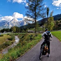
04 schongau a fussen
A cycling route starting in Schongau, Bavaria, Germany.
Overview
About this route
- -:--
- Duration
- 45.1 km
- Distance
- 546 m
- Ascent
- 458 m
- Descent
- ---
- Avg. speed
- 817 m
- Max. altitude

Route quality
Waytypes & surfaces along the route
Waytypes
Quiet road
19.4 km
(43 %)
Path
11.3 km
(25 %)
Surfaces
Paved
37.9 km
(84 %)
Unpaved
6.3 km
(14 %)
Asphalt
36.1 km
(80 %)
Gravel
2.7 km
(6 %)
Route highlights
Points of interest along the route
Point of interest after 0 km
Continue with Bikemap
Use, edit, or download this cycling route
You would like to ride 04 schongau a fussen or customize it for your own trip? Here is what you can do with this Bikemap route:
Free features
- Save this route as favorite or in collections
- Copy & plan your own version of this route
- Sync your route with Garmin or Wahoo
Premium features
Free trial for 3 days, or one-time payment. More about Bikemap Premium.
- Navigate this route on iOS & Android
- Export a GPX / KML file of this route
- Create your custom printout (try it for free)
- Download this route for offline navigation
Discover more Premium features.
Get Bikemap PremiumFrom our community
Other popular routes starting in Schongau
 2005 Schongau - Ammersee
- Distance
- 50.1 km
- Ascent
- 291 m
- Descent
- 449 m
- Location
- Schongau, Bavaria, Germany
 Tag 2: von Schongau nach Ehrwald
- Distance
- 80.1 km
- Ascent
- 915 m
- Descent
- 695 m
- Location
- Schongau, Bavaria, Germany
 Schongau - Hoher Peißenberg - Schongau
- Distance
- 37.7 km
- Ascent
- 481 m
- Descent
- 480 m
- Location
- Schongau, Bavaria, Germany
 shongau - donauworth
- Distance
- 117.3 km
- Ascent
- 109 m
- Descent
- 356 m
- Location
- Schongau, Bavaria, Germany
 04 schongau a fussen
- Distance
- 45.1 km
- Ascent
- 546 m
- Descent
- 458 m
- Location
- Schongau, Bavaria, Germany
 LechwegTag3
- Distance
- 46.3 km
- Ascent
- 316 m
- Descent
- 238 m
- Location
- Schongau, Bavaria, Germany
 Mittelmäßige Lech-Ammerseerunde Schongau - Utting
- Distance
- 93.1 km
- Ascent
- 421 m
- Descent
- 421 m
- Location
- Schongau, Bavaria, Germany
 TA02-Schongau-Ehrwald-77km
- Distance
- 37.3 km
- Ascent
- 263 m
- Descent
- 182 m
- Location
- Schongau, Bavaria, Germany
Open it in the app