GjwsD trasa 4
A cycling route starting in Ostrołęka, Masovian Voivodeship, Poland.
Overview
About this route
- -:--
- Duration
- 61.3 km
- Distance
- 82 m
- Ascent
- 83 m
- Descent
- ---
- Avg. speed
- ---
- Max. altitude
Route quality
Waytypes & surfaces along the route
Waytypes
Road
46 km
(75 %)
Quiet road
13.5 km
(22 %)
Undefined
1.8 km
(3 %)
Surfaces
Paved
61.3 km
(100 %)
Asphalt
61.3 km
(100 %)
Route highlights
Points of interest along the route
Drinking water after 41.5 km
Tu lokalny rowerzysta próbował się popisać
Continue with Bikemap
Use, edit, or download this cycling route
You would like to ride GjwsD trasa 4 or customize it for your own trip? Here is what you can do with this Bikemap route:
Free features
- Save this route as favorite or in collections
- Copy & plan your own version of this route
- Sync your route with Garmin or Wahoo
Premium features
Free trial for 3 days, or one-time payment. More about Bikemap Premium.
- Navigate this route on iOS & Android
- Export a GPX / KML file of this route
- Create your custom printout (try it for free)
- Download this route for offline navigation
Discover more Premium features.
Get Bikemap PremiumFrom our community
Other popular routes starting in Ostrołęka
Sobótkowa do Generała Zygmunta Padlewskiego- Distance
- 19.7 km
- Ascent
- 169 m
- Descent
- 199 m
- Location
- Ostrołęka, Masovian Voivodeship, Poland
MP 196 - GOOD Route- Distance
- 6.3 km
- Ascent
- 16 m
- Descent
- 12 m
- Location
- Ostrołęka, Masovian Voivodeship, Poland
MP 6.1 OSTROŁĘKA - FINAŁOWA- Distance
- 6.1 km
- Ascent
- 9 m
- Descent
- 8 m
- Location
- Ostrołęka, Masovian Voivodeship, Poland
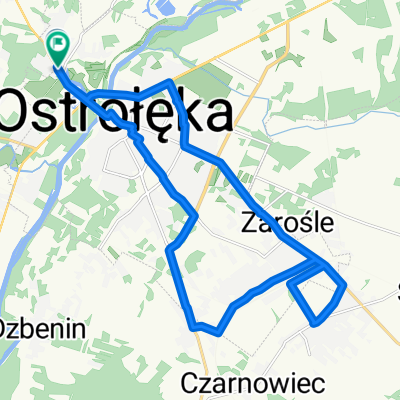
Franciszka Stefczyka 33, Ostrołęka do Franciszka Stefczyka 33, Ostrołęka- Distance
- 15.8 km
- Ascent
- 27 m
- Descent
- 63 m
- Location
- Ostrołęka, Masovian Voivodeship, Poland
Rajd 26.09.2020- Distance
- 35.5 km
- Ascent
- 70 m
- Descent
- 70 m
- Location
- Ostrołęka, Masovian Voivodeship, Poland
GjwsD trasa 4- Distance
- 61.3 km
- Ascent
- 82 m
- Descent
- 83 m
- Location
- Ostrołęka, Masovian Voivodeship, Poland
Wypad i rozpoznanie- Distance
- 162.1 km
- Ascent
- 264 m
- Descent
- 264 m
- Location
- Ostrołęka, Masovian Voivodeship, Poland
MP 68 - GOOD Route - Pętla Rzekuń- Distance
- 2.7 km
- Ascent
- 4 m
- Descent
- 4 m
- Location
- Ostrołęka, Masovian Voivodeship, Poland
Open it in the app

